
Mapa topográfico Steiner Ranch
Haga clic en el mapa para ver la altitud.
Acerca de este mapa
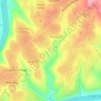
Nombre: Mapa topográfico Steiner Ranch, altitud, relieve.
Lugar: Steiner Ranch, Travis County, Texas, 78732, United States (30.34569 -97.90942 30.36569 -97.88942)
Altitud media: 221 m
Altitud mínima: 141 m
Altitud máxima: 285 m
Otros mapas topográficos
Haga clic en un mapa para ver su topografía, su altitud y su relieve.
Austin
United States > Texas > Travis County
Austin features a diverse and varied topography shaped by its position along the Balcones Fault. The city’s elevation ranges from about 425 feet to approximately 1,000 feet above sea level, creating a landscape characterized by rolling hills and elevated areas particularly in the western regions. To the…
Altitud media: 216 m
Austin
United States > Texas > Travis County
The elevation of Austin varies from 425 feet (130 m) to approximately 1,000 feet (305 m) above sea level. Due to the fact it straddles the Balcones Fault, much of the eastern part of the city is flat, with heavy clay and loam soils, whereas the western part and western suburbs consist of rolling hills on the…
Altitud media: 216 m
Lago Vista
United States > Texas > Travis County
Lago Vista is situated on the northern shore of Lake Travis within the Texas Hill Country. The area's terrain is notably rugged, with steep limestone hills and canyons. Elevations range from about 774 feet near the lake to 1,220 feet near Rusty Allen Airport, making it one of the highest points in Travis…
Altitud media: 251 m
Roy G. Guerrero Colorado River Metro Park
United States > Texas > Travis County > Austin
Altitud media: 141 m
Bee Cave
United States > Texas > Travis County
According to the United States Census Bureau in 2010, the city has a total area of 2.6 square miles (6.7 km2), all of it land. Prior to the 2010 census, Bee Cave went from being a village to being a city, increasing its area to 6.8 square miles (18 km2), all land. It borders Lakeway to the northwest. The…
Altitud media: 270 m
Circle C Ranch Metropolitan Park on Slaughter Creek
United States > Texas > Travis County > Austin
Altitud media: 259 m
Shoal Beach at Town Lake Metropolitan Park
United States > Texas > Travis County > Austin
Altitud media: 152 m
Austin
United States > Texas > Travis County
The elevation of Austin varies from 425 feet (130 m) to approximately 1,000 feet (305 m) above sea level. Due to the fact it straddles the Balcones Fault, much of the eastern part of the city is flat, with heavy clay and loam soils, whereas the western part and western suburbs consist of rolling hills on the…
Altitud media: 216 m
Lago Vista
United States > Texas > Travis County
According to the United States Census Bureau, the city has a total area of 15.52 sq mi (40.2 km2) of which 14.6 sq mi (38 km2) is land and 0.6 sq mi (1.6 km2) (3.95%) is water. The peninsular city sits adjacent to, and partially within, the Balcones Canyonlands. Lago Vista has rugged terrain with elevations…
Altitud media: 251 m
Bee Cave
United States > Texas > Travis County
According to the United States Census Bureau in 2010, the city has a total area of 2.6 square miles (6.7 km2), all of it land. Prior to the 2010 census, Bee Cave went from being a village to being a city, increasing its area to 6.8 square miles (18 km2), all land. It borders Lakeway to the northwest. The…
Altitud media: 270 m
Austin
United States > Texas > Travis County
The elevation of Austin varies from 425 feet (130 m) to approximately 1,000 feet (305 m) above sea level. Due to the fact it straddles the Balcones Fault, much of the eastern part of the city is flat, with heavy clay and loam soils, whereas the western part and western suburbs consist of rolling hills on the…
Altitud media: 216 m