
Mapa topográfico Bee Cave
Haga clic en el mapa para ver la altitud.
Bee Cave
According to the United States Census Bureau in 2010, the city has a total area of 2.6 square miles (6.7 km2), all of it land. Prior to the 2010 census, Bee Cave went from being a village to being a city, increasing its area to 6.8 square miles (18 km2), all land. It borders Lakeway to the northwest. The landscape of Bee Cave is generally hilly, with elevations ranging from 875 to 1025 feet (265–310 m).
Acerca de este mapa
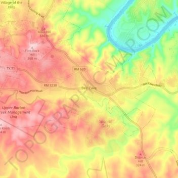
Nombre: Mapa topográfico Bee Cave, altitud, relieve.
Lugar: Bee Cave, Travis County, Texas, United States (30.28614 -98.00369 30.32981 -97.90868)
Altitud media: 270 m
Altitud mínima: 148 m
Altitud máxima: 363 m
Otros mapas topográficos
Haga clic en un mapa para ver su topografía, su altitud y su relieve.
Roy G. Guerrero Colorado River Metro Park
United States > Texas > Travis County > Austin
Altitud media: 141 m
Austin
United States > Texas > Travis County > Austin
The elevation of Austin varies from 425 feet (130 m) to approximately 1,000 feet (305 m) above sea level. Due to the fact it straddles the Balcones Fault, much of the eastern part of the city is flat, with heavy clay and loam soils, whereas the western part and western suburbs consist of rolling hills on the…
Altitud media: 203 m