
Gracias por apoyar a este sitio ❤️
Haz una donación
Haz una donación
Mapa topográfico Homewood
Haga clic en el mapa para ver la altitud.
Gracias por apoyar a este sitio ❤️
Haz una donación
Haz una donación
Homewood
Homewood was located on the Atchison, Topeka and Santa Fe Railway at altitude 1,039 feet (317 m) above sea level. In 1900, it contained a population of about 100 inhabitants. Around this time, a number of stores operated out of the community, and it also had its own school. It was the supply and shipping point for the surrounding rural area.
Gracias por apoyar a este sitio ❤️
Haz una donación
Haz una donación
Acerca de este mapa
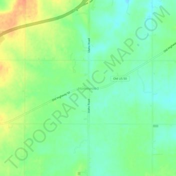
Nombre: Mapa topográfico Homewood, altitud, relieve.
Lugar: Homewood, Franklin County, Kansas, United States (38.49474 -95.39887 38.53474 -95.35887)
Altitud media: 320 m
Altitud mínima: 302 m
Altitud máxima: 347 m
Gracias por apoyar a este sitio ❤️
Haz una donación
Haz una donación
Otros mapas topográficos
Haga clic en un mapa para ver su topografía, su altitud y su relieve.