
Gracias por apoyar a este sitio ❤️
Haz una donación
Haz una donación
Mapa topográfico Pomona
Haga clic en el mapa para ver la altitud.
Gracias por apoyar a este sitio ❤️
Haz una donación
Haz una donación
Acerca de este mapa
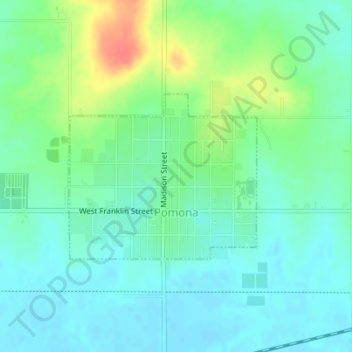
Nombre: Mapa topográfico Pomona, altitud, relieve.
Lugar: Pomona, Franklin County, Kansas, United States (38.60476 -95.46220 38.61744 -95.44371)
Altitud media: 294 m
Altitud mínima: 279 m
Altitud máxima: 332 m
Gracias por apoyar a este sitio ❤️
Haz una donación
Haz una donación
Otros mapas topográficos
Haga clic en un mapa para ver su topografía, su altitud y su relieve.
Homewood
United States > Kansas > Franklin County
Homewood was located on the Atchison, Topeka and Santa Fe Railway at altitude 1,039 feet (317 m) above sea level. In 1900, it contained a population of about 100 inhabitants. Around this time, a number of stores operated out of the community, and it also had its own school. It was the supply and shipping point…
Altitud media: 320 m