
Haz una donación
Mapa topográfico Tenaya Lake
Haga clic en el mapa para ver la altitud.
Haz una donación
Tenaya Lake
Tenaya Lake is an alpine lake in Yosemite National Park, located between Yosemite Valley and Tuolumne Meadows. The surface of Tenaya Lake has an elevation of 8,150 feet (2,484 m). The lake basin was formed by glacial action, which left a backdrop of light granite rocks, whose beauty was known to the Native Americans. Today, Tenaya Lake is easily accessible by State Route 120 and is a popular lake for water activities.
Haz una donación
Acerca de este mapa
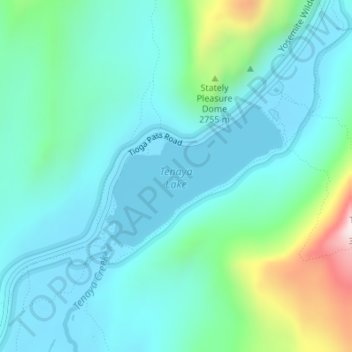
Nombre: Mapa topográfico Tenaya Lake, altitud, relieve.
Lugar: Tenaya Lake, Mariposa County, California, United States (37.82571 -119.46821 37.83649 -119.45109)
Altitud media: 2.605 m
Altitud mínima: 2.485 m
Altitud máxima: 3.092 m
Haz una donación
Otros mapas topográficos
Haga clic en un mapa para ver su topografía, su altitud y su relieve.
Mariposa
United States > California > Mariposa County
Mariposa is located at 37°29′06″N 119°57′59″W / 37.48500°N 119.96639°W / 37.48500; -119.96639, at 1,949 feet (594 m) in elevation. It lies in the rugged foothills of the Sierra Nevada. Mariposa Creek flows through the town. Soils in the urban area are mostly brown to reddish brown loam of…
Altitud media: 688 m
Yosemite Valley
United States > California > Mariposa County > Yosemite Village > Yosemite Lodge
Altitud media: 1.479 m
Glacier Point
United States > California > Mariposa County > Curry Village
Glacier Point is a viewpoint above Yosemite Valley in the U.S. state of California. It is located on the south wall of Yosemite Valley at an elevation of 7,214 feet (2,199 m), 3,200 feet (980 m) above Curry Village. The point offers a superb view of several of Yosemite National Park's well-known landmarks,…
Altitud media: 1.711 m
Haz una donación
Falls View
United States > California > Mariposa County > Yosemite Village > Yosemite Lodge
Altitud media: 1.538 m
Glacier Point
United States > California > Mariposa County > Curry Village
Glacier Point is a viewpoint above Yosemite Valley in the U.S. state of California. It is located on the south wall of Yosemite Valley at an elevation of 7,214 feet (2,199 m), 3,200 feet (980 m) above Curry Village. The point offers a superb view of several of Yosemite National Park's well-known landmarks,…
Altitud media: 1.775 m
Haz una donación
Haz una donación
Haz una donación