
Haz una donación
Mapa topográfico Mount Broderick
Haga clic en el mapa para ver la altitud.
Haz una donación
Acerca de este mapa
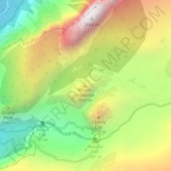
Nombre: Mapa topográfico Mount Broderick, altitud, relieve.
Altitud media: 1.904 m
Altitud mínima: 1.238 m
Altitud máxima: 2.693 m
Haz una donación
Otros mapas topográficos
Haga clic en un mapa para ver su topografía, su altitud y su relieve.
Mariposa
United States > California > Mariposa County > Mariposa
Mariposa is located at 37°29′06″N 119°57′59″W / 37.48500°N 119.96639°W / 37.48500; -119.96639, at 1,949 feet (594 m) in elevation. It lies in the rugged foothills of the Sierra Nevada. Mariposa Creek flows through the town. Soils in the urban area are mostly brown to reddish brown loam of…
Altitud media: 686 m
Tenaya Lake
United States > California > Mariposa County
Tenaya Lake is an alpine lake in Yosemite National Park, located between Yosemite Valley and Tuolumne Meadows. The surface of Tenaya Lake has an elevation of 8,150 feet (2,484 m). The lake basin was formed by glacial action, which left a backdrop of light granite rocks, whose beauty was known to the Native…
Altitud media: 2.605 m