
Haz una donación
Mapa topográfico Highwood
Haga clic en el mapa para ver la altitud.
Haz una donación
Highwood
Highwood is located in southeastern Lake County at 42°12′19″N 87°48′44″W / 42.205357°N 87.812345°W / 42.205357; -87.812345, on a ridge 100 feet (30 m) above the elevation of Lake Michigan.
Haz una donación
Acerca de este mapa
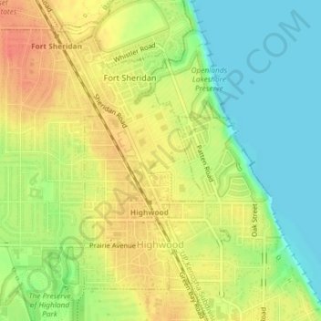
Nombre: Mapa topográfico Highwood, altitud, relieve.
Lugar: Highwood, Lake County, Illinois, 60040, United States (42.19608 -87.82154 42.21779 -87.80438)
Altitud media: 198 m
Altitud mínima: 174 m
Altitud máxima: 220 m
Haz una donación
Otros mapas topográficos
Haga clic en un mapa para ver su topografía, su altitud y su relieve.
Sand Lake
United States > Illinois > Lake County > Lindenhurst > Venetian Village
Altitud media: 240 m
Haz una donación
Waukegan
United States > Illinois > Lake County > Waukegan
Waukegan is located at 42°22′13″N 87°52′16″W / 42.37028°N 87.87111°W / 42.37028; -87.87111 (42.3703140, −87.8711404). Waukegan is on the shore of Lake Michigan, about 11 miles (18 km) south of the border with Wisconsin and 41 miles (66 km) north of downtown Chicago, at an elevation of…
Altitud media: 200 m
Haz una donación
Bull Creek Terrace
United States > Illinois > Lake County > Beach Park > Bull Creek Terrace
Altitud media: 199 m
Haz una donación
Founders Park, Beach Park Il
United States > Illinois > Lake County > Beach Park > Beach Park Country Estates
Altitud media: 195 m
Haz una donación