
Gracias por apoyar a este sitio ❤️
Haz una donación
Haz una donación
Mapa topográfico Taneyville
Haga clic en el mapa para ver la altitud.
Gracias por apoyar a este sitio ❤️
Haz una donación
Haz una donación
Taneyville
Taneyville is located in north-central Taney County. The town lies along Missouri Route 76 between Bradleyville and Kissee Mills. The townsite is on a northeast–southwest trending ridge between Swan Creek to the northwest and Beaver Creek to the southeast. The site is at an elevation of 1,073 ft (327 m).
Gracias por apoyar a este sitio ❤️
Haz una donación
Haz una donación
Acerca de este mapa
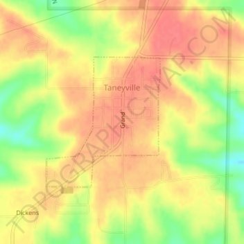
Nombre: Mapa topográfico Taneyville, altitud, relieve.
Lugar: Taneyville, Taney County, Missouri, 65759, United States (36.73039 -93.04480 36.74482 -93.02906)
Altitud media: 312 m
Altitud mínima: 273 m
Altitud máxima: 333 m
Gracias por apoyar a este sitio ❤️
Haz una donación
Haz una donación
Otros mapas topográficos
Haga clic en un mapa para ver su topografía, su altitud y su relieve.
Silver Dollar City's WhiteWater
United States > Missouri > Taney County > Branson
Altitud media: 296 m
Gracias por apoyar a este sitio ❤️
Haz una donación
Haz una donación