
Haz una donación
Mapa topográfico McClurg
Haga clic en el mapa para ver la altitud.
Haz una donación
Acerca de este mapa
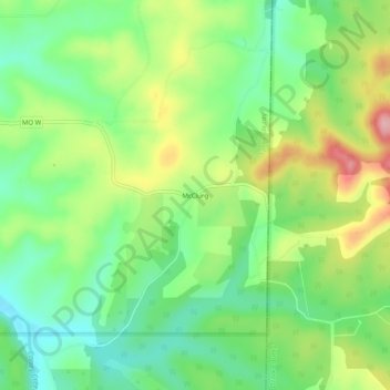
Nombre: Mapa topográfico McClurg, altitud, relieve.
Lugar: McClurg, Taney County, Missouri, United States (36.76450 -92.79489 36.80450 -92.75489)
Altitud media: 347 m
Altitud mínima: 286 m
Altitud máxima: 443 m
Haz una donación
Otros mapas topográficos
Haga clic en un mapa para ver su topografía, su altitud y su relieve.
Branson
United States > Missouri > Taney County
Branson features a diverse and picturesque topography characterized by rolling hills, deep valleys, and abundant water features. Nestled in the Ozark Mountains, the area has an elevation that typically ranges around 778 feet (237 meters) above sea level. The region is shaped by its proximity to several lakes,…
Altitud media: 275 m
Taneyville
United States > Missouri > Taney County
Taneyville is located in north-central Taney County. The town lies along Missouri Route 76 between Bradleyville and Kissee Mills. The townsite is on a northeast–southwest trending ridge between Swan Creek to the northwest and Beaver Creek to the southeast. The site is at an elevation of 1,073 ft (327 m).
Altitud media: 312 m
Haz una donación
Silver Dollar City's WhiteWater
United States > Missouri > Taney County > Branson
Altitud media: 296 m
Haz una donación
Haz una donación