
Mapa topográfico Kitzbühel
Mapa interactivo
Haga clic en el mapa para ver la altitud.
Acerca de este mapa
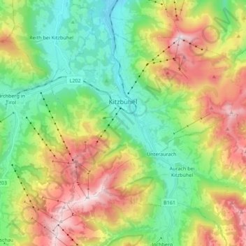
Nombre: Mapa topográfico Kitzbühel, altitud, relieve.
Lugar: Kitzbühel, Bezirk Kitzbühel, 6370, Austria (47.39505 12.34109 47.47793 12.50914)
Altitud media: 1.176 m
Altitud mínima: 692 m
Altitud máxima: 1.974 m
Otros mapas topográficos
Haga clic en un mapa para ver su topografía, su altitud y su relieve.
Scheffau
Austria > Bezirk Kitzbühel > Sankt Johann in Tirol
Scheffau, Sankt Johann in Tirol, Bezirk Kitzbühel, Austria
Altitud media: 939 m
Mittagskogel
Austria > Bezirk Kitzbühel > Jochberg
Mittagskogel, Jochberg, Bezirk Kitzbühel, Austria
Altitud media: 1.838 m
Gemeinde Kössen
Gemeinde Kössen, Bezirk Kitzbühel, Tyrol, 6345, Austria
Altitud media: 979 m