
Mapa topográfico Densole
Mapa interactivo
Haga clic en el mapa para ver la altitud.
Acerca de este mapa
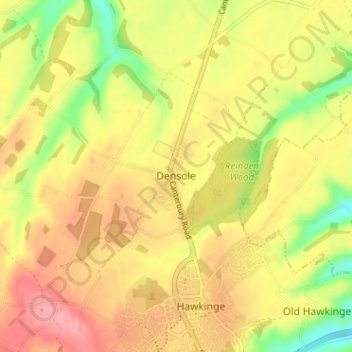
Nombre: Mapa topográfico Densole, altitud, relieve.
Altitud media: 146 m
Altitud mínima: 89 m
Altitud máxima: 189 m
Otros mapas topográficos
Haga clic en un mapa para ver su topografía, su altitud y su relieve.
Hythe
United Kingdom > England > Kent > Folkestone and Hythe District
Hythe, Folkestone and Hythe District, Kent, England, United Kingdom
Altitud media: 32 m
Folkestone
United Kingdom > England > Kent > Folkestone and Hythe District
Folkestone, Folkestone and Hythe District, Kent, England, United Kingdom
Altitud media: 62 m
Park Gate
United Kingdom > England > Kent > Folkestone and Hythe District > Elham
Park Gate, Elham, Folkestone and Hythe District, Kent, England, CT4 6BH, United Kingdom
Altitud media: 130 m
Lympne
United Kingdom > England > Kent > Folkestone and Hythe District
Lympne, Folkestone and Hythe District, Kent, England, United Kingdom
Altitud media: 56 m
Littlestone on Sea
United Kingdom > England > Kent > Folkestone and Hythe District > New Romney
Littlestone on Sea, New Romney, Folkestone and Hythe District, Kent, England, TN28 8QU, United Kingdom
Altitud media: 1 m