
Haz una donación
Mapa topográfico Avala
Haga clic en el mapa para ver la altitud.
Haz una donación
Avala
It is still debated whether Šuplja Stena is a natural cave or was completely dug for the mining purposes. Remains of the Neanderthal culture were discovered in it. In his 1943 Prehistoric mine Šuplja Stena on Avala hill near Belgrade (Serbia), Vladimir Milojčić said that the "cave is old as Avala", formed by the volcanic activity and elevation of the terrain. The cave was first used by the wild animals and later by the prehistoric peoples, with animal and human remains, and prehistoric mining artefacts have been discovered. However, geographer Dragan Petrović in his work on the caves of Šumadija, lists caves on the present Belgrade's territory, but makes no mention of Šuplja Stena.
Haz una donación
Acerca de este mapa
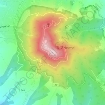
Nombre: Mapa topográfico Avala, altitud, relieve.
Lugar: Avala, City of Belgrade, Central Serbia, 11223, Serbia (44.68904 20.51589 44.68914 20.51599)
Altitud media: 297 m
Altitud mínima: 162 m
Altitud máxima: 500 m
Haz una donación
Otros mapas topográficos
Haga clic en un mapa para ver su topografía, su altitud y su relieve.
Zemun
Serbia > Central Serbia > City of Belgrade > Zemun Urban Municipality
One of the characteristics of the Zemun's topography are the lagums, artificial underground corridors which crisscross below the loess area of Gardoš, Muhar, Ćukovac and Kalvarija. This terrain is one of the most active landslide areas in Belgrade. Being cut into for centuries, the loess in some sections…
Altitud media: 80 m
Haz una donación
Drazevac
Serbia > Central Serbia > City of Belgrade > Obrenovac Urban Municipality
Altitud media: 115 m
Haz una donación
Ropocevo
Serbia > Central Serbia > City of Belgrade > Sopot Urban Municipality
Ropočevo is located on the Ripanj Plateau of the Kosmaj mountain, spreading over the altitudes from 195 to 248 m (640 to 814 ft). It is situated in the spring area of Veliki Lug, a tributary to the Kubršnica. There are several other water springs in the village area: Drmink, Alinac, Pavitine, Glogovac, etc.…
Altitud media: 242 m
Mala Mostanica
Serbia > Central Serbia > City of Belgrade > Obrenovac Urban Municipality
Altitud media: 155 m
Haz una donación
Haz una donación
Cibutkovica
Serbia > Central Serbia > City of Belgrade > Lazarevac Urban Municipality
Altitud media: 170 m
Haz una donación
Haz una donación
Great War Island
Serbia > Central Serbia > City of Belgrade > Zemun Urban Municipality
Altitud media: 75 m
Mladenovac
Serbia > Central Serbia > City of Belgrade > Mladenovac Urban Municipality
Altitud media: 165 m
Grabovac
Serbia > Central Serbia > City of Belgrade > Obrenovac Urban Municipality
Altitud media: 91 m
Velika Ivanca
Serbia > Central Serbia > City of Belgrade > Mladenovac Urban Municipality
Altitud media: 221 m
Haz una donación
Dubona
Serbia > Central Serbia > City of Belgrade > Mladenovac Urban Municipality
Altitud media: 249 m
Haz una donación
Beli Potok
Serbia > Central Serbia > City of Belgrade > Vozdovac Urban Municipality
Altitud media: 218 m
Haz una donación
Brajkovac
Serbia > Central Serbia > City of Belgrade > Lazarevac Urban Municipality
Altitud media: 236 m
Vrbovno
Serbia > Central Serbia > City of Belgrade > Lazarevac Urban Municipality
Altitud media: 142 m
Haz una donación
Banovo Brdo
Serbia > Central Serbia > City of Belgrade > Belgrade
New building of the Faculty of forestry was built in 1956, right above Careva Ćuprija, where the northwest section of the vast wood of Košutnjak begins at an altitude of 110-125 meters. Professors and students began developing a dendrology collection in 1957, which grew into the Arboretum of the Faculty of…
Altitud media: 99 m
Haz una donación
Beli Potok
Serbia > Central Serbia > City of Belgrade > Vozdovac Urban Municipality
Altitud media: 218 m
Колубара
Serbia > Central Serbia > City of Belgrade > Lazarevac Urban Municipality
Altitud media: 108 m
Haz una donación