
Haz una donación
Mapa topográfico Rancho Peñasquitos
Haga clic en el mapa para ver la altitud.
Haz una donación
Rancho Peñasquitos
The highest point in the community is Black Mountain, which rises to an elevation of 1,500 feet (460 m).
Haz una donación
Acerca de este mapa
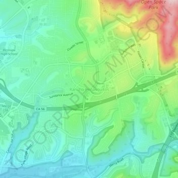
Nombre: Mapa topográfico Rancho Peñasquitos, altitud, relieve.
Altitud media: 157 m
Altitud mínima: 62 m
Altitud máxima: 385 m
Haz una donación
Otros mapas topográficos
Haga clic en un mapa para ver su topografía, su altitud y su relieve.
Cabrillo National Monument
United States > California > San Diego County > San Diego
The Old Point Loma Lighthouse is the highest point in the park and has been a San Diego icon since 1855. The lighthouse was closed in 1891, and the New Point Loma Lighthouse opened at a lower elevation, as fog and low clouds often obscured the light at its location 129 meters (422 feet) above sea level. The…
Altitud media: 13 m
Haz una donación
Torrey Pines State Natural Reserve
United States > California > San Diego County > San Diego
Altitud media: 37 m
Lake Murray Reservoir
United States > California > San Diego County > San Diego > San Carlos
Altitud media: 178 m
Haz una donación
Los Peñasquitos Canyon Preserve
United States > California > San Diego County > San Diego > Sorrento Valley
Altitud media: 95 m