
Haz una donación
Mapa topográfico Balboa Park
Haga clic en el mapa para ver la altitud.
Haz una donación
Acerca de este mapa
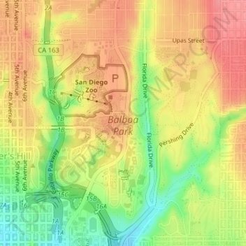
Nombre: Mapa topográfico Balboa Park, altitud, relieve.
Altitud media: 73 m
Altitud mínima: 24 m
Altitud máxima: 108 m
Haz una donación
Otros mapas topográficos
Haga clic en un mapa para ver su topografía, su altitud y su relieve.
Lake Murray Reservoir
United States > California > San Diego County > San Diego > San Carlos
Altitud media: 178 m
Haz una donación
San Diego
United States > California > San Diego County > San Diego
The climate in San Diego, like most of Southern California, often varies significantly over short geographical distances, resulting in microclimates. In San Diego, this is mostly because of the city's topography (the Bay, and the numerous hills, mountains, and canyons). Frequently, particularly during the "May…
Altitud media: 57 m
Rancho Peñasquitos
United States > California > San Diego County > San Diego
The highest point in the community is Black Mountain, which rises to an elevation of 1,500 feet (460 m).
Altitud media: 157 m
Haz una donación
Torrey Pines State Natural Reserve
United States > California > San Diego County > San Diego
Altitud media: 37 m
Haz una donación
Haz una donación