
Gracias por apoyar a este sitio ❤️
Haz una donación
Haz una donación
Mapa topográfico Coyote Creek
Haga clic en el mapa para ver la altitud.
Gracias por apoyar a este sitio ❤️
Haz una donación
Haz una donación
Acerca de este mapa
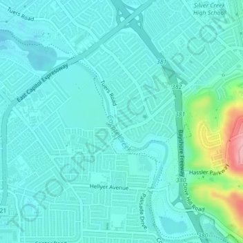
Nombre: Mapa topográfico Coyote Creek, altitud, relieve.
Altitud media: 58 m
Altitud mínima: 36 m
Altitud máxima: 175 m
Gracias por apoyar a este sitio ❤️
Haz una donación
Haz una donación
Otros mapas topográficos
Haga clic en un mapa para ver su topografía, su altitud y su relieve.
Gracias por apoyar a este sitio ❤️
Haz una donación
Haz una donación
Almaden Quicksilver County Park
United States > California > Santa Clara County > San Jose
Almaden Quicksilver County Park is a 4,163 acres (17 km²) park that includes the grounds of former mercury ("quicksilver") mines adjacent to south San Jose, California, USA. The park's elevation varies greatly: the most used entrances (on the east side of the park) are less than 600 feet (183 m) above sea…
Altitud media: 267 m
Santa Teresa County Park
United States > California > Santa Clara County > San Jose
Altitud media: 150 m