
Gracias por apoyar a este sitio ❤️
Haz una donación
Haz una donación
Mapa topográfico Almaden Quicksilver County Park
Haga clic en el mapa para ver la altitud.
Gracias por apoyar a este sitio ❤️
Haz una donación
Haz una donación
Almaden Quicksilver County Park
Almaden Quicksilver County Park is a 4,163 acres (17 km²) park that includes the grounds of former mercury ("quicksilver") mines adjacent to south San Jose, California, USA. The park's elevation varies greatly: the most used entrances (on the east side of the park) are less than 600 feet (183 m) above sea level, while the highest point in the park is over 1,700 feet (518 m) above sea level.
Gracias por apoyar a este sitio ❤️
Haz una donación
Haz una donación
Acerca de este mapa
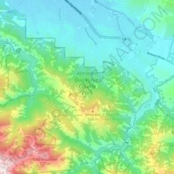
Nombre: Mapa topográfico Almaden Quicksilver County Park, altitud, relieve.
Altitud media: 267 m
Altitud mínima: 77 m
Altitud máxima: 809 m
Gracias por apoyar a este sitio ❤️
Haz una donación
Haz una donación
Otros mapas topográficos
Haga clic en un mapa para ver su topografía, su altitud y su relieve.
Gracias por apoyar a este sitio ❤️
Haz una donación
Haz una donación
Sierra Vista Open Space Preserve
United States > California > Santa Clara County > San Jose
Altitud media: 484 m
Gracias por apoyar a este sitio ❤️
Haz una donación
Haz una donación