
Mapa topográfico White County
Mapa interactivo
Haga clic en el mapa para ver la altitud.
Acerca de este mapa
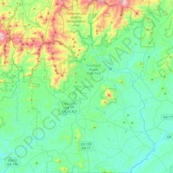
Nombre: Mapa topográfico White County, altitud, relieve.
Lugar: White County, Georgia, United States (34.50359 -83.87735 34.80137 -83.61559)
Altitud media: 556 m
Altitud mínima: 337 m
Altitud máxima: 1.333 m
The county is mostly located in the foothills of the Blue Ridge Mountains. Northern parts of the county have the highest elevations, being in the mountains themselves. The highest point in White County is 4,430-foot (1,350 m) Tray Mountain, shared with Towns County to the north. Tray Mountain is the 6th-highest mountain in Georgia. Another very prominent White County peak is Yonah Mountain, also known as Mount Yonah. This 3,143-foot (958 m) peak, located between Helen and Cleveland, is rimmed by sheer cliffs and is the highest point on Georgia's Piedmont Plateau.
Otros mapas topográficos
Haga clic en un mapa para ver su topografía, su altitud y su relieve.
Athens
United States > Georgia > Athens
Athens, Athens-Clarke County, Georgia, 303341458, United States
Altitud media: 221 m
Atlanta
United States > Georgia > Fulton County
Atlanta, Fulton County, Georgia, United States
Altitud media: 284 m
Savannah
United States > Georgia > Chatham County
Savannah, Chatham County, Georgia, United States
Altitud media: 4 m
Tybee Island
United States > Georgia > Chatham County
Tybee Island, Chatham County, Georgia, 31328, United States
Altitud media: 1 m
Columbus
United States > Georgia > Muscogee County
Columbus, Muscogee County, Georgia, United States
Altitud media: 130 m
Blue Ridge
United States > Georgia > Fannin County
Blue Ridge, Fannin County, Georgia, United States
Altitud media: 535 m
Blairsville
United States > Georgia > Union County
Blairsville, Union County, Georgia, United States
Altitud media: 587 m
Saint Simons Island
United States > Georgia > Glynn County
Saint Simons Island, Glynn County, Georgia, 31561, United States
Altitud media: 2 m
Dahlonega
United States > Georgia > Lumpkin County
Dahlonega, Lumpkin County, Georgia, United States
Altitud media: 411 m
Whigham
United States > Georgia > Grady County
Whigham, Grady County, Georgia, United States
Altitud media: 85 m
Atlanta
United States > Georgia > Fulton County
Atlanta, Fulton County, Georgia, 30303, United States
Altitud media: 285 m
Augusta
United States > Georgia > Augusta
Augusta, Richmond County, Georgia, 30901, United States
Altitud media: 90 m
Concord
United States > Georgia > Pike County
Concord, Pike County, Georgia, United States
Altitud media: 249 m
Ellijay
United States > Georgia > Gilmer County
Ellijay, Gilmer County, Georgia, 30540, United States
Altitud media: 424 m
Fort Yargo State Park
United States > Georgia > Barrow County > Winder
Fort Yargo State Park, Winder, Barrow County, Georgia, United States
Altitud media: 270 m
Gainesville
United States > Georgia > Hall County
Gainesville, Hall County, Georgia, 30501, United States
Altitud media: 346 m
Macon
United States > Georgia > Bibb County
Macon, Bibb County, Georgia, United States
Altitud media: 127 m
Radio Springs
United States > Georgia > Floyd County
Radio Springs, Floyd County, Georgia, United States
Altitud media: 243 m
Brunswick
United States > Georgia > Glynn County
Brunswick, Glynn County, Georgia, United States
Altitud media: 2 m
Vinings
United States > Georgia > Cobb County
Vinings, Cobb County, Georgia, 30339, United States
Altitud media: 281 m
Helen
United States > Georgia > White County
Helen, White County, Georgia, 30545, United States
Altitud media: 488 m
Hiawassee
United States > Georgia > Towns County
Hiawassee, Towns County, Georgia, United States
Altitud media: 620 m
Wilscot
United States > Georgia > Fannin County
Wilscot, Fannin County, Georgia, United States
Altitud media: 614 m
Robins Air Force Base
United States > Georgia > Houston County
Robins Air Force Base, Houston County, Georgia, 31098, United States
Altitud media: 92 m
Georgia International Horse Park
United States > Georgia > Rockdale County > Conyers
Georgia International Horse Park, Conyers, Rockdale County, Georgia, United States
Altitud media: 209 m
Alpharetta
United States > Georgia > Fulton County
Alpharetta, Fulton County, Georgia, United States
Altitud media: 324 m
Skidaway Island
United States > Georgia > Chatham County
Skidaway Island, Chatham County, Georgia, 31411, United States
Altitud media: 3 m
Canton
United States > Georgia > Cherokee County
Canton, Cherokee County, Georgia, United States
Altitud media: 320 m
Kennesaw
United States > Georgia > Cobb County
Kennesaw, Cobb County, Georgia, 30144, United States
Altitud media: 317 m
Lumpkin
United States > Georgia > Stewart County
Lumpkin, Stewart County, Georgia, United States
Altitud media: 147 m
Jointer Island
United States > Georgia > Glynn County > Brunswick
Jointer Island, Brunswick, Glynn County, Georgia, United States
Altitud media: 0 m
Heritage Acres
United States > Georgia > Bibb County > Macon
Heritage Acres, Macon, Bibb County, Georgia, 31211, United States
Altitud media: 119 m
Stone Mountain
United States > Georgia > DeKalb County
Stone Mountain, DeKalb County, Georgia, 30087, United States
Altitud media: 299 m
Woodstock
United States > Georgia > Cherokee County
Woodstock, Cherokee County, Georgia, United States
Altitud media: 296 m
Lake Oconee
United States > Georgia > Greene County > Lake Oconee
Lake Oconee, Greene County, Georgia, United States
Altitud media: 165 m
Mountain City
United States > Georgia > Rabun County
Mountain City, Rabun County, Georgia, 30562, United States
Altitud media: 747 m
Iron Mountain
United States > Georgia > Murray County
Iron Mountain, Murray County, Georgia, United States
Altitud media: 362 m
Fort Pulaski
United States > Georgia > Chatham County
Fort Pulaski, Fort Perimeter Trail, Chatham County, Georgia, 31328, United States
Altitud media: 1 m