
Haz una donación
Mapa topográfico Carroll County
Haga clic en el mapa para ver la altitud.
Haz una donación
Carroll County
Carroll County occupies a rolling section of Georgia’s western Piedmont, a landscape of modest but persistent relief shaped by weathered crystalline bedrock, narrow valleys, and rounded upland ridges. The county’s elevations rise from lower ground along the Chattahoochee River corridor on the southeastern margin to higher ridgelines in the northwest and southwest, culminating around Blackjack Mountain, the county high point at roughly 1,553 feet (473 meters). Around Carrollton and the central county, the terrain is gently to moderately undulating, with broad interfluves separated by the creek valleys of the Little Tallapoosa River system, while the southeast drains toward the Chattahoochee basin. This drainage divide gives the county a subtly tiered physical structure, with streams cutting shallow hollows through the Piedmont upland and producing a varied pattern of slopes, low ridges, and small valley floors. Overall, Carroll County presents a classic inland Piedmont topography: not mountainous, but distinctly hilly, dissected, and elevated enough to create a strong sense of relief across its rural and urban landscapes.
Haz una donación
Acerca de este mapa
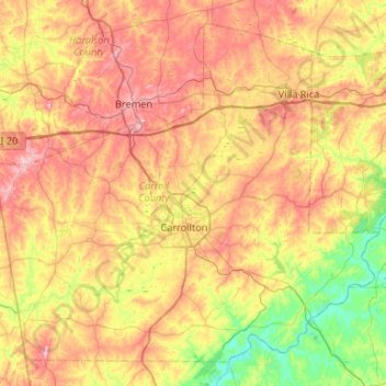
Nombre: Mapa topográfico Carroll County, altitud, relieve.
Lugar: Carroll County, Georgia, United States (33.42561 -85.33820 33.81247 -84.80893)
Altitud media: 325 m
Altitud mínima: 205 m
Altitud máxima: 468 m
Haz una donación
Otros mapas topográficos
Haga clic en un mapa para ver su topografía, su altitud y su relieve.
Atlanta
United States > Georgia > Fulton County
Atlanta occupies a high, rolling part of the Georgia Piedmont, a physiographic region described as a landscape of low hills and narrow valleys between the Blue Ridge Mountains and the Upper Coastal Plain. Around downtown and Fulton County, the terrain is gently dissected rather than flat, with broad urban…
Altitud media: 285 m
Augusta
United States > Georgia > Augusta
As with the rest of the state, Augusta has a humid subtropical climate (Köppen Cfa), with short, mild winters, very hot, humid summers, and a wide diurnal temperature variation throughout much of the year, despite its low elevation and moisture. The monthly daily average temperature ranges from 45.4 °F (7.4…
Altitud media: 90 m
Haz una donación
Haz una donación
Haz una donación
Haz una donación
Haz una donación
Haz una donación
Haz una donación
Haz una donación
Haz una donación
Haz una donación
Climax
United States > Georgia > Decatur County
Climax was platted in 1833, and named for its lofty elevation. The Georgia General Assembly incorporated the place in 1905 as the "Town of Climax", with the municipal corporate limits extending in a one-half mile radius from the town's central water well.
Altitud media: 90 m
Haz una donación
Haz una donación
Haz una donación
Haz una donación
Spring Valley Estates
United States > Georgia > Athens-Clarke County > Athens-Clarke County Unified Government
Altitud media: 218 m
Haz una donación
Haz una donación
Potato Hill Civil War Battlefield Park
United States > Georgia > Whitfield County > Dalton
Altitud media: 257 m
Haz una donación
Haz una donación
Haz una donación
Haz una donación
Haz una donación
Haz una donación
Haz una donación
Haz una donación
Georgia International Horse Park
United States > Georgia > Rockdale County > Conyers
Altitud media: 209 m
Haz una donación