
Gracias por apoyar a este sitio ❤️
Haz una donación
Haz una donación
Mapa topográfico Pinnacle Mountain
Haga clic en el mapa para ver la altitud.
Gracias por apoyar a este sitio ❤️
Haz una donación
Haz una donación
Acerca de este mapa
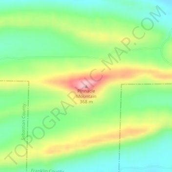
Nombre: Mapa topográfico Pinnacle Mountain, altitud, relieve.
Lugar: Pinnacle Mountain, Franklin County, Arkansas, United States (35.21365 -94.05331 35.21375 -94.05321)
Altitud media: 253 m
Altitud mínima: 183 m
Altitud máxima: 364 m
Gracias por apoyar a este sitio ❤️
Haz una donación
Haz una donación
Otros mapas topográficos
Haga clic en un mapa para ver su topografía, su altitud y su relieve.
Altus
United States > Arkansas > Franklin County > Altus
Altus had its start in 1875 when the railroad was extended to that point. Altus station was the highest point on the track. In recognition of this highest railroad elevation between Little Rock and Fort Smith, the station was originally known as "Summit". The town's initial development was due to railroad…
Altitud media: 192 m