
Haz una donación
Mapa topográfico Watson
Haga clic en el mapa para ver la altitud.
Haz una donación
Acerca de este mapa
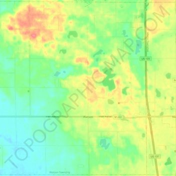
Nombre: Mapa topográfico Watson, altitud, relieve.
Lugar: Watson, Allegan County, Michigan, United States (42.50786 -85.78129 42.59489 -85.66176)
Altitud media: 242 m
Altitud mínima: 211 m
Altitud máxima: 286 m
Haz una donación
Otros mapas topográficos
Haga clic en un mapa para ver su topografía, su altitud y su relieve.
Haz una donación
Haz una donación
Mount Baldhead
United States > Michigan > Allegan County > Saugatuck
Mount Baldhead, also known as Mt. Baldy and Radar Hill, is a 250-foot (76-meter) sand dune located on a narrow strip of land between Lake Michigan and Kalamazoo River, directly across the river from downtown Saugatuck. It has an elevation of 807 feet (246 meters) and is about 70 miles (110 kilometers) north of…
Altitud media: 184 m
Haz una donación
Haz una donación
Haz una donación
Trowbridge Township
United States > Michigan > Allegan County
Merson is an unincorporated community in the township at the junction of M-40 and 102 Avenue (42°26′05″N 85°51′58″W / 42.43472°N 85.86611°W / 42.43472; -85.86611 Elevation: 761 ft./232 m.).
Altitud media: 225 m
Haz una donación