
Gracias por apoyar a este sitio ❤️
Haz una donación
Haz una donación
Mapa topográfico Macomb Township
Haga clic en el mapa para ver la altitud.
Gracias por apoyar a este sitio ❤️
Haz una donación
Haz una donación
Acerca de este mapa
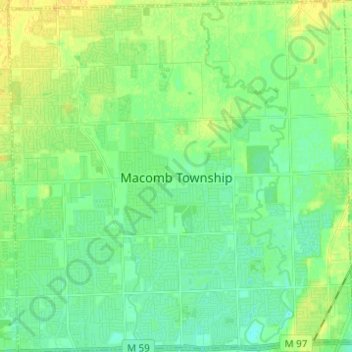
Nombre: Mapa topográfico Macomb Township, altitud, relieve.
Lugar: Macomb Township, Macomb County, Michigan, United States (42.62753 -82.97691 42.71813 -82.85610)
Altitud media: 186 m
Altitud mínima: 178 m
Altitud máxima: 197 m
Gracias por apoyar a este sitio ❤️
Haz una donación
Haz una donación
Otros mapas topográficos
Haga clic en un mapa para ver su topografía, su altitud y su relieve.
Anchor Bay Shores
United States > Michigan > Macomb County > Chesterfield Township
Altitud media: 176 m
Preston Corners
United States > Michigan > Macomb County > Shelby Charter Township
Altitud media: 198 m
Gracias por apoyar a este sitio ❤️
Haz una donación
Haz una donación
Shelby Charter Township
United States > Michigan > Macomb County > Shelby Charter Township
Altitud media: 205 m
Sterling Heights
United States > Michigan > Macomb County > Sterling Heights > Sterling Heights
Altitud media: 205 m