
Haz una donación
Mapa topográfico Mount Lukens
Haga clic en el mapa para ver la altitud.
Haz una donación
Mount Lukens
It is in the Sunland-Tujunga community within the northeast corner of the city of Los Angeles, above the Crescenta Valley. The summit, at 5,075 feet (1,547 m) in elevation, is the highest point within the city limits. The summit's elevation makes Los Angeles the city with the largest difference between high and low points among the 50 most populous cities in the US.
Haz una donación
Acerca de este mapa
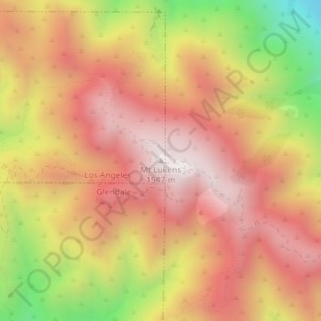
Nombre: Mapa topográfico Mount Lukens, altitud, relieve.
Altitud media: 1.176 m
Altitud mínima: 584 m
Altitud máxima: 1.541 m
Haz una donación
Otros mapas topográficos
Haga clic en un mapa para ver su topografía, su altitud y su relieve.
West Hills Neighborhood Council District
United States > California > Los Angeles County > Los Angeles
Altitud media: 319 m
Los Angeles City Council District 7
United States > California > Los Angeles County > Los Angeles
Altitud media: 512 m
Haz una donación
Los Angeles City Council District 5
United States > California > Los Angeles County > Los Angeles
Altitud media: 131 m
Santa Ynez Reservoir
United States > California > Los Angeles County > Los Angeles
Altitud media: 307 m
Pacific Palisades
United States > California > Los Angeles County > Los Angeles
Pacific Palisades was formally founded in 1921 by a Methodist organization, and in the years that followed became a refuge for Jewish artists and intellectuals fleeing the Holocaust. The Palisades would later be sought after by celebrities and other high-profile individuals seeking privacy. It is known for its…
Altitud media: 196 m
Haz una donación
Haz una donación
Los Angeles City Council District 6
United States > California > Los Angeles County > Los Angeles
Altitud media: 252 m
Haz una donación
Arleta Neighborhood Council District
United States > California > Los Angeles County > Los Angeles
Altitud media: 274 m
Augustus F. Hawkins Natural Park
United States > California > Los Angeles County > Los Angeles
Altitud media: 55 m
Haz una donación