
Haz una donación
Mapa topográfico Boyle Heights
Haga clic en el mapa para ver la altitud.
Haz una donación
Acerca de este mapa
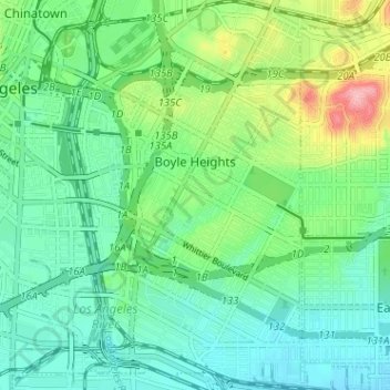
Nombre: Mapa topográfico Boyle Heights, altitud, relieve.
Altitud media: 91 m
Altitud mínima: 54 m
Altitud máxima: 189 m
Haz una donación
Otros mapas topográficos
Haga clic en un mapa para ver su topografía, su altitud y su relieve.
Santa Ynez Reservoir
United States > California > Los Angeles County > Los Angeles
Altitud media: 307 m
Mount Lukens
United States > California > Los Angeles County > Los Angeles
It is in the Sunland-Tujunga community within the northeast corner of the city of Los Angeles, above the Crescenta Valley. The summit, at 5,075 feet (1,547 m) in elevation, is the highest point within the city limits. The summit's elevation makes Los Angeles the city with the largest difference between high…
Altitud media: 1.176 m
Haz una donación
Augustus F. Hawkins Natural Park
United States > California > Los Angeles County > Los Angeles
Altitud media: 55 m
Haz una donación