
Haz una donación
Mapa topográfico Shasta
Haga clic en el mapa para ver la altitud.
Haz una donación
Shasta
Shasta is a census-designated place (CDP) in Shasta County, California, United States. Shasta sits at an elevation of 843 feet (257 m). Its population is 1,043 as of the 2020 census, down from 1,771 from the 2010 census.
Haz una donación
Acerca de este mapa
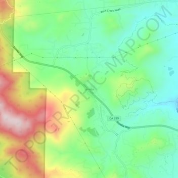
Nombre: Mapa topográfico Shasta, altitud, relieve.
Lugar: Shasta, Shasta County, California, 96087, United States (40.57932 -122.51196 40.61932 -122.47196)
Altitud media: 351 m
Altitud mínima: 197 m
Altitud máxima: 628 m
Haz una donación
Otros mapas topográficos
Haga clic en un mapa para ver su topografía, su altitud y su relieve.
Palo Cedro
United States > California > Shasta County > Palo Cedro
Palo Cedro is located at 40°33′4″N 122°14′3″W / 40.55111°N 122.23417°W / 40.55111; -122.23417 (40.551091, −122.234255) at an elevation of 465 ft (143 m) above sea level.
Altitud media: 157 m
Haz una donación
Haz una donación