
Haz una donación
Mapa topográfico Lake Britton
Haga clic en el mapa para ver la altitud.
Haz una donación
Acerca de este mapa
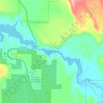
Nombre: Mapa topográfico Lake Britton, altitud, relieve.
Lugar: Lake Britton, Shasta County, California, United States (40.98968 -121.67683 41.03770 -121.57645)
Altitud media: 939 m
Altitud mínima: 834 m
Altitud máxima: 1.259 m
Haz una donación
Otros mapas topográficos
Haga clic en un mapa para ver su topografía, su altitud y su relieve.
Redding
United States > California > Shasta County > Redding
The elevation in Redding is 495 feet (151 meters) on average, whereas anywhere to the north, east, or west of downtown ranges between 550 feet (170 m) and 800 feet (240 m) feet. Southern portions range between 400 feet (120 m) and 500 feet (150 m).
Altitud media: 312 m
Haz una donación
Cassel
United States > California > Shasta County
Cassel is a census-designated place (CDP) in Shasta County, California. Cassel sits at an elevation of 3,176 feet (968 m). Its population is 207 as of the 2020 census, remaining the same from the 2010 census. The ZIP Code is 96016. The community is inside area code 530.
Altitud media: 972 m
Shasta
United States > California > Shasta County
Shasta is a census-designated place (CDP) in Shasta County, California, United States. Shasta sits at an elevation of 843 feet (257 m). Its population is 1,043 as of the 2020 census, down from 1,771 from the 2010 census.
Altitud media: 351 m
Haz una donación
Haz una donación
Haz una donación
Haz una donación