
Gracias por apoyar a este sitio ❤️
Haz una donación
Haz una donación
Mapa topográfico Beaver
Haga clic en el mapa para ver la altitud.
Gracias por apoyar a este sitio ❤️
Haz una donación
Haz una donación
Acerca de este mapa
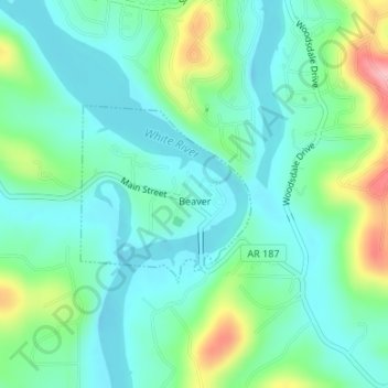
Nombre: Mapa topográfico Beaver, altitud, relieve.
Lugar: Beaver, Carroll County, Arkansas, 72613, United States (36.46897 -93.77903 36.48134 -93.76429)
Altitud media: 314 m
Altitud mínima: 275 m
Altitud máxima: 424 m
Gracias por apoyar a este sitio ❤️
Haz una donación
Haz una donación
Otros mapas topográficos
Haga clic en un mapa para ver su topografía, su altitud y su relieve.
Gracias por apoyar a este sitio ❤️
Haz una donación
Haz una donación
Eureka Springs
United States > Arkansas > Carroll County > Eureka Springs
It is a tourist destination for its unique character as a Victorian resort village. The city has steep winding streets filled with Victorian-style cottages and manors. The historic commercial downtown of the city has an extensive streetscape of well-preserved Victorian buildings. The buildings are primarily…
Altitud media: 417 m