
Haz una donación
Mapa topográfico Laramie
Haga clic en el mapa para ver la altitud.
Haz una donación
Laramie
Laramie is on a high plain between two mountain ranges, the Snowy Range, about 30 miles (48 km) to the west, and the Laramie Range, 7 miles (11 km) to the east. The city's elevation above sea level is approximately 7,165 feet (2,184 m). The Laramie River runs through Laramie toward its confluence with the North Platte River east of the Laramie Range.
Haz una donación
Acerca de este mapa
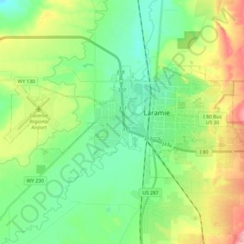
Nombre: Mapa topográfico Laramie, altitud, relieve.
Lugar: Laramie, Albany County, Wyoming, United States (41.27742 -105.69729 41.33581 -105.52819)
Altitud media: 2.219 m
Altitud mínima: 2.166 m
Altitud máxima: 2.462 m
Haz una donación
Otros mapas topográficos
Haga clic en un mapa para ver su topografía, su altitud y su relieve.
Medicine Bow Peak
United States > Wyoming > Albany County
Medicine Bow Peak (12,018 ft (3,663 m)) is the highest peak in the Snowy Range, a part of the Medicine Bow Mountains, about 35 miles (56 km) west of Laramie, Wyoming. It lies within Medicine Bow National Forest and is the highest point in southern Wyoming. The summit lies in extreme western Albany County, but…
Altitud media: 3.396 m
Laramie
United States > Wyoming > Albany County
Laramie (/ˈlærəmi/) is a city in and the county seat of Albany County, Wyoming, United States, known for its high elevation at 7,200 feet (2,200 m), railroad history, and is the home of the University of Wyoming. The population was 31,407 at the 2020 census, making it the fourth-most populous city in…
Altitud media: 2.218 m
Laramie
United States > Wyoming > Albany County
Laramie (/ˈlærəmi/) is a city in and the county seat of Albany County, Wyoming, United States, known for its high elevation at 7,200 feet (2,200 m), for its railroad history, and as the home of the University of Wyoming. The population was 31,407 at the 2020 census, making it the fourth-most populous city…
Altitud media: 2.218 m
Haz una donación
Laramie
United States > Wyoming > Albany County > Laramie
Laramie is on a high plain between two mountain ranges, the Snowy Range, about 30 miles (48 km) to the west, and the Laramie Range, 7 miles (11 km) to the east. The city's elevation above sea level is approximately 7,165 feet (2,184 m). The Laramie River runs through Laramie toward its confluence with the…
Altitud media: 2.299 m