Mapa topográfico Tekoa
Haga clic en el mapa para ver la altitud.
Tekoa
Tekoa was incorporated in 1889 with just under 300 people at the base of Tekoa Mountain (elevation 2,490 feet), on the extreme eastern end of the Palouse, and to the west of the Benewah Range of Idaho. In 1908 the railroad trestle above the town was built. By 1910 the population had grown to 1,694. Over the next 60 years, Tekoa began a population decline as mechanized farming reduced the need for workers, and railway was abandoned. By 1990 the town had fewer than 750 residents, but during the 1990s the population rose to 826 at the 2000 census.
Acerca de este mapa
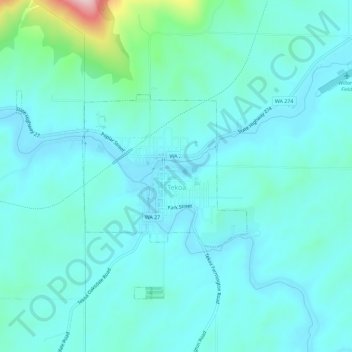
Nombre: Mapa topográfico Tekoa, altitud, relieve.
Lugar: Tekoa, Whitman County, Washington, 99033, United States (47.21105 -117.09695 47.23817 -117.03972)
Altitud media: 792 m
Altitud mínima: 754 m
Altitud máxima: 1.015 m
Otros mapas topográficos
Haga clic en un mapa para ver su topografía, su altitud y su relieve.

Colfax
United States > Washington > Whitman County > Colfax > Colfax
Colfax is located in southeastern Washington at 46°53′3″N 117°21′49″W / 46.88417°N 117.36361°W / 46.88417; -117.36361 (46.884033, -117.363668), at an elevation of 1,962 feet (598 m). The nearest cities are Spokane, Pullman, Moscow, and Lewiston/Clarkston. The area is geologically…
Altitud media: 689 m