
Mapa topográfico Belle Isle
Mapa interactivo
Haga clic en el mapa para ver la altitud.
Acerca de este mapa
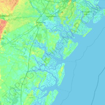
Nombre: Mapa topográfico Belle Isle, altitud, relieve.
Lugar: Belle Isle, Bryan County, Georgia, United States (31.44244 -81.54038 32.08244 -80.90038)
Altitud media: 4 m
Altitud mínima: -4 m
Altitud máxima: 34 m
Otros mapas topográficos
Haga clic en un mapa para ver su topografía, su altitud y su relieve.
Keller
United States > Georgia > Bryan County
Keller, Bryan County, Georgia, United States
Altitud media: 5 m
Richmond Hill
United States > Georgia > Bryan County
Richmond Hill, Bryan County, Georgia, United States
Altitud media: 5 m
Pembroke
United States > Georgia > Bryan County > Pembroke
Pembroke, Bryan County, Georgia, United States
Altitud media: 26 m
Blitchton
United States > Georgia > Bryan County > Blitchton
Blitchton, Bryan County, Georgia, 31308, United States
Altitud media: 21 m
Ellabell
United States > Georgia > Bryan County > Ellabell
Ellabell, Bryan County, Georgia, United States
Altitud media: 21 m