
Haz una donación
Mapa topográfico Sandy
Haga clic en el mapa para ver la altitud.
Haz una donación
Acerca de este mapa
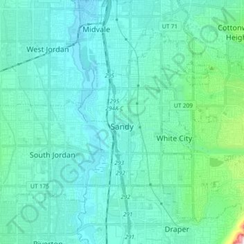
Nombre: Mapa topográfico Sandy, altitud, relieve.
Lugar: Sandy, Salt Lake County, Utah, United States (40.52766 -111.92162 40.61801 -111.77686)
Altitud media: 1.376 m
Altitud mínima: 1.304 m
Altitud máxima: 1.896 m
Haz una donación
Otros mapas topográficos
Haga clic en un mapa para ver su topografía, su altitud y su relieve.
Jordan River OHV/ Modelport State Park
United States > Utah > Salt Lake County > Salt Lake City
Altitud media: 1.286 m
Haz una donación
Haz una donación
Haz una donación
Haz una donación
Haz una donación
Salt Lake City
United States > Utah > Salt Lake County > Salt Lake City
Salt Lake City has an area of 110.4 square miles (286 km2) and an average elevation of 4,327 feet (1,319 m) above sea level. The lowest point within the boundaries of the city is 4,210 feet (1,280 m) near the Jordan River and the Great Salt Lake, and the highest is Grandview Peak, at 9,410 feet (2,868 m).
Altitud media: 1.625 m
Meridian Peak
United States > Utah > Salt Lake County > Salt Lake City
Meridian Peak can be found at the southern end of Elliot Ridge Trail. It can be reached by ascending several hiking trails into the Gore Range. Surprise Lake Trail goes south for 2.6 miles to Surprise Lake, then the Gore Range Trail continues west for 1.9 miles to a junction with the Upper Cataract Lake and…
Altitud media: 1.698 m
Haz una donación
Brighton
United States > Utah > Salt Lake County
Brighton has a high-altitude cold continental climate (Köppen Dsb/Dsc), with dry summers and very snowy winters.
Altitud media: 2.852 m
Haz una donación