
Haz una donación
Mapa topográfico Port Charlotte
Haga clic en el mapa para ver la altitud.
Haz una donación
Port Charlotte
Port Charlotte is characterized by a predominantly flat and low-lying terrain, typical of Florida’s coastal landscape. The area features a network of waterways, including the Peace River and Charlotte Harbor, which provide ample opportunities for recreational activities like boating and fishing. Elevations are generally modest, with the highest points rarely exceeding 30 feet above sea level. The region is dotted with numerous canals, many of which are navigable, enhancing the community's waterfront appeal. The surrounding environment includes patches of subtropical vegetation and wetlands, contributing to the area's biodiversity and scenic beauty. Overall, Port Charlotte's topography, with its gentle contours and extensive water features, creates a picturesque setting that reflects the charm of Florida's Gulf Coast.
Haz una donación
Acerca de este mapa
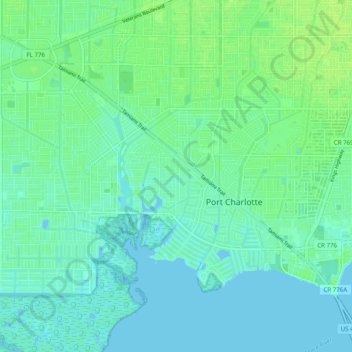
Nombre: Mapa topográfico Port Charlotte, altitud, relieve.
Lugar: Port Charlotte, Charlotte County, Florida, United States (26.94693 -82.15629 27.01802 -82.05760)
Altitud media: 4 m
Altitud mínima: -2 m
Altitud máxima: 10 m
Haz una donación
Otros mapas topográficos
Haga clic en un mapa para ver su topografía, su altitud y su relieve.
Punta Gorda
United States > Florida > Charlotte County
Punta Gorda features a predominantly flat topography characterized by its low elevation, averaging around 7 to 10 feet above sea level. The terrain is primarily made up of coastal plains and wetlands, interspersed with small hills such as those found in South Punta Gorda Heights, which can reach elevations of…
Altitud media: 3 m
Punta Gorda Isles
United States > Florida > Charlotte County > Punta Gorda > Punta Gorda Isles
Altitud media: 2 m
Haz una donación
Haz una donación
Haz una donación
Haz una donación
Haz una donación
Haz una donación
Placida
United States > Florida > Charlotte County
Placida is located at 26°49′55″N 82°15′54″W / 26.83194°N 82.265°W / 26.83194; -82.265Coordinates: 26°49′55″N 82°15′54″W / 26.83194°N 82.265°W / 26.83194; -82.265 (26.83194, -82.265). Placida has an elevation of 3 feet.
Altitud media: 1 m
Haz una donación