
Mapa topográfico Cleveland
Haga clic en el mapa para ver la altitud.
Acerca de este mapa
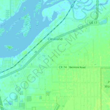
Nombre: Mapa topográfico Cleveland, altitud, relieve.
Lugar: Cleveland, Charlotte County, Florida, 33951, United States (26.92484 -82.02063 26.98185 -81.95927)
Altitud media: 4 m
Altitud mínima: -2 m
Altitud máxima: 10 m
Otros mapas topográficos
Haga clic en un mapa para ver su topografía, su altitud y su relieve.
Port Charlotte
United States > Florida > Charlotte County
Port Charlotte is characterized by a predominantly flat and low-lying terrain, typical of Florida’s coastal landscape. The area features a network of waterways, including the Peace River and Charlotte Harbor, which provide ample opportunities for recreational activities like boating and fishing. Elevations…
Altitud media: 4 m
Peace River Botanical & Sculpture Gardens
United States > Florida > Charlotte County > Punta Gorda
Altitud media: 3 m
Punta Gorda Isles
United States > Florida > Charlotte County > Punta Gorda > Punta Gorda Isles
Altitud media: 2 m
Placida
United States > Florida > Charlotte County
Placida is located at 26°49′55″N 82°15′54″W / 26.83194°N 82.265°W / 26.83194; -82.265Coordinates: 26°49′55″N 82°15′54″W / 26.83194°N 82.265°W / 26.83194; -82.265 (26.83194, -82.265). Placida has an elevation of 3 feet.
Altitud media: 1 m
Harbour Heights
United States > Florida > Charlotte County > Punta Gorda > Harbour Heights
Altitud media: 4 m
Peace River Preserve
United States > Florida > Charlotte County > Punta Gorda > Harbour Heights
Altitud media: 3 m
Heritage Lake Park Community Development District
United States > Florida > Charlotte County
Altitud media: 7 m
Gilcrest Park
United States > Florida > Charlotte County > Punta Gorda > Fishermens Village
Altitud media: 2 m