
Haz una donación
Mapa topográfico The Carousel
Haga clic en el mapa para ver la altitud.
Haz una donación
Acerca de este mapa
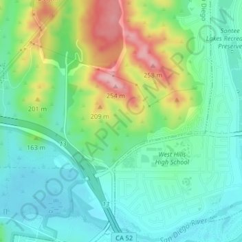
Nombre: Mapa topográfico The Carousel, altitud, relieve.
Altitud media: 137 m
Altitud mínima: 85 m
Altitud máxima: 251 m
Haz una donación
Otros mapas topográficos
Haga clic en un mapa para ver su topografía, su altitud y su relieve.
Lake Murray Reservoir
United States > California > San Diego County > San Diego > San Carlos
Altitud media: 178 m
Los Peñasquitos Canyon Preserve
United States > California > San Diego County > San Diego > Sorrento Valley
Altitud media: 95 m
Haz una donación
Cabrillo National Monument
United States > California > San Diego County > San Diego
The Old Point Loma Lighthouse is the highest point in the park and has been a San Diego icon since 1855. The lighthouse was closed in 1891, and the New Point Loma Lighthouse opened at a lower elevation, as fog and low clouds often obscured the light at its location 129 meters (422 feet) above sea level. The…
Altitud media: 13 m
Haz una donación
Mission Trails Regional Park
United States > California > San Diego County > San Diego > San Carlos
Altitud media: 178 m
Torrey Pines State Natural Reserve
United States > California > San Diego County > San Diego
Altitud media: 37 m
Haz una donación