
Haz una donación
Mapa topográfico Palm Springs
Haga clic en el mapa para ver la altitud.
Haz una donación
Palm Springs
Palm Springs, located in the Coachella Valley, is characterized by striking topography shaped by both the Colorado Desert and surrounding mountain ranges. The city lies at an average elevation of around 480 feet (146 meters) above sea level. To the west, the San Bernardino Mountains rise dramatically, with peaks such as Mount San Jacinto reaching over 10,800 feet (3,292 meters), offering a sharp contrast to the valley floor. These mountains provide the area with stunning vistas and are a major factor in the region's climate, contributing to the desert's heat while also forming part of the San Bernardino National Forest. The desert landscape itself features sandy terrain interspersed with rocky outcrops, and the valley floor gradually slopes downward towards areas like the Salton Sea to the southeast, which sits far below sea level.
Haz una donación
Acerca de este mapa
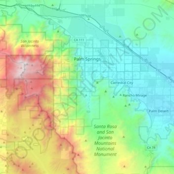
Nombre: Mapa topográfico Palm Springs, altitud, relieve.
Lugar: Palm Springs, Riverside County, California, United States (33.61242 -116.71209 33.93198 -116.44280)
Altitud media: 859 m
Altitud mínima: 41 m
Altitud máxima: 3.277 m
Haz una donación
Otros mapas topográficos
Haga clic en un mapa para ver su topografía, su altitud y su relieve.
Idyllwild-Pine Cove
United States > California > Riverside County
"Mile-high Idyllwild" is a mountain resort about one-mile (1,600 m) in altitude. Idyllwild is flanked by two large rock formations, Tahquitz Peak and Suicide Rock (also known as Lily Rock), which are famous in Southern California rock-climbing circles. It offers no skiing, so "the Hill" has been minimally…
Altitud media: 1.746 m
Menifee
United States > California > Riverside County
Menifee is a city in Riverside County, California, United States, and part of the Los Angeles Combined Statistical Area. The city is centrally located in Southern California in the Menifee Valley. It is almost 15 miles (24 km) north of Temecula and just north of Murrieta. Menifee is roughly 46 square miles…
Altitud media: 456 m
Pinyon Pines
United States > California > Riverside County
It is located in a small valley between the San Jacinto Mountains and Santa Rosa Mountains, north of State Route 74. It takes its name from the Pinyon pine (Pinus monophylla) trees native to the area. Pinyon Pines sits at an elevation of approximately 4000 feet.
Altitud media: 1.276 m
Haz una donación
San Gorgonio Pass
United States > California > Riverside County
The San Gorgonio Pass, or Banning Pass, is a 2,600 ft (790 m) elevation gap on the rim of the Great Basin between the San Bernardino Mountains to the north and the San Jacinto Mountains to the south. The pass was formed by the San Andreas Fault, a major transform fault between the Pacific plate and the North…
Altitud media: 492 m
Haz una donación
Haz una donación
Agua Caliente Park
United States > California > Riverside County > Cathedral City
Altitud media: 121 m
Haz una donación
Haz una donación
El Cerrito
United States > California > Riverside County
According to the United States Census Bureau, the city has a total area of 3.7 square miles (9.6 km2), all of it land. The city ranges in elevation from 20 to 934 feet, with an average elevation of 69 feet (21 m).
Altitud media: 293 m
Haz una donación
Sunnymead Ranch Lake
United States > California > Riverside County > Moreno Valley
Altitud media: 575 m
Haz una donación
Arlington Station
United States > California > Riverside County > Riverside
Arlington Station (formerly, Arlington) is a former unincorporated community, now annexed to Riverside in Riverside County, California. It lies at an elevation of 817 feet (249 m). Arlington Station is located on the Atchison, Topeka and Santa Fe Railroad, 6 miles (9.7 km) southwest of downtown Riverside.
Altitud media: 252 m
Haz una donación
Highgrove
United States > California > Riverside County
The city of Riverside, California has plans to annex Highgrove in the near future. Currently at Spring Mountain Ranch community, Avalon, Cambria, and Sonoma (all opening by February 2022) are the three, newest largest master-planned communities being built at the Highgrove eastside area. Soon, Compass and…
Altitud media: 316 m
Mountain Center
United States > California > Riverside County
It lies centered on the junction of State Route 74 and State Route 243 in the southern division of San Bernardino National Forest. Mountain Center lies just north of Lake Hemet, midway between Hemet and Palm Desert, just south of the town of Idyllwild, and it is southeast of the city of Riverside, the county…
Altitud media: 1.476 m
Haz una donación
Haz una donación
Haz una donación
Haz una donación
Bannockburn Village
United States > California > Riverside County > Riverside > Bannockburn Village
Altitud media: 336 m
Haz una donación
Bogart County Park
United States > California > Riverside County > Highland Springs
Altitud media: 973 m