
Haz una donación
Mapa topográfico Midland
Haga clic en el mapa para ver la altitud.
Haz una donación
Acerca de este mapa
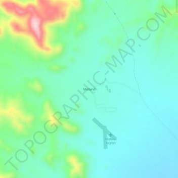
Nombre: Mapa topográfico Midland, altitud, relieve.
Lugar: Midland, Riverside County, California, United States (33.84113 -114.82219 33.88113 -114.78219)
Altitud media: 330 m
Altitud mínima: 259 m
Altitud máxima: 554 m
Haz una donación
Otros mapas topográficos
Haga clic en un mapa para ver su topografía, su altitud y su relieve.
Palm Springs
United States > California > Riverside County
Palm Springs, located in the Coachella Valley, is characterized by striking topography shaped by both the Colorado Desert and surrounding mountain ranges. The city lies at an average elevation of around 480 feet (146 meters) above sea level. To the west, the San Bernardino Mountains rise dramatically, with…
Altitud media: 859 m
Idyllwild-Pine Cove
United States > California > Riverside County
"Mile-high Idyllwild" is a mountain resort about one-mile (1,600 m) in altitude. Idyllwild is flanked by two large rock formations, Tahquitz Peak and Suicide Rock (also known as Lily Rock), which are famous in Southern California rock-climbing circles. It offers no skiing, so "the Hill" has been minimally…
Altitud media: 1.746 m
Sunnymead Ranch Lake
United States > California > Riverside County > Moreno Valley
Altitud media: 575 m
Haz una donación
Bermuda Dunes
United States > California > Riverside County > Palm Desert
According to the United States Census Bureau, the CDP has a total area of 2.9 square miles (7.5 km2), all of it land. The official elevation of Bermuda Dunes is 30 feet (9.1 m) above sea level, but the surface drops by over 80 feet (24 m) from west to east.
Altitud media: 27 m
Palm Desert
United States > California > Riverside County
The elevation (City hall) is 224 feet (68 m) above sea level. Elevations vary from the lower northern half once covered in sand dunes to the upper slope southern cove (300–900 feet or 91–274 metres) all the way to the ridgeline at 1,000 feet (over 300 meters). Palm Desert is located in the Coachella…
Altitud media: 298 m
Haz una donación
Haz una donación
Haz una donación
Agua Caliente Park
United States > California > Riverside County > Cathedral City
Altitud media: 121 m
Lake Mathews
United States > California > Riverside County
Lake Mathews was constructed in a basin formerly traversed by Cajalco Creek; thus, any water flowing down the creek enters the reservoir. Cajalco Creek is a tributary of the Santa Ana River via Cajalco Canyon Creek into Temescal Creek. The original course of the creek, before 1933, can be seen on the US Dept.…
Altitud media: 430 m
El Cerrito
United States > California > Riverside County
According to the United States Census Bureau, the city has a total area of 3.7 square miles (9.6 km2), all of it land. The city ranges in elevation from 20 to 934 feet, with an average elevation of 69 feet (21 m).
Altitud media: 293 m
Haz una donación
Coronita
United States > California > Riverside County
Coronita (Spanish for "Small crown") is a census-designated place in Riverside County, California. Coronita sits at an elevation of 630 feet (190 m). The 2010 United States census reported Coronita's population was 2,608.
Altitud media: 227 m
Haz una donación
Coachella
United States > California > Riverside County
The elevation is 68 feet (21 m) below sea level, as the eastern half of the Coachella Valley is below sea level. The saltwater lake, Salton Sea, 10 miles (16 km) south of Coachella, is 228 feet (69 m) below sea level.
Altitud media: -2 m
Whitewater
United States > California > Riverside County
Whitewater (formerly, White Water) is a census-designated place in Riverside County, California. It is directly off Interstate 10 halfway between North Palm Springs and Cabazon on the way from Palm Springs to Los Angeles. It is known as the site of the San Gorgonio Pass Wind Farm. The ZIP Code is 92282, and…
Altitud media: 530 m
Haz una donación
Highgrove
United States > California > Riverside County
The city of Riverside, California has plans to annex Highgrove in the near future. Currently at Spring Mountain Ranch community, Avalon, Cambria, and Sonoma (all opening by February 2022) are the three, newest largest master-planned communities being built at the Highgrove eastside area. Soon, Compass and…
Altitud media: 316 m
Mountain Center
United States > California > Riverside County
It lies centered on the junction of State Route 74 and State Route 243 in the southern division of San Bernardino National Forest. Mountain Center lies just north of Lake Hemet, midway between Hemet and Palm Desert, just south of the town of Idyllwild, and it is southeast of the city of Riverside, the county…
Altitud media: 1.476 m
Haz una donación
Haz una donación
Bogart County Park
United States > California > Riverside County > Highland Springs
Altitud media: 973 m