
Mapa topográfico Col de Portes
Mapa interactivo
Haga clic en el mapa para ver la altitud.
Acerca de este mapa
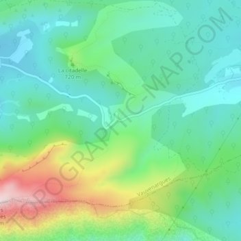
Nombre: Mapa topográfico Col de Portes, altitud, relieve.
Altitud media: 663 m
Altitud mínima: 530 m
Altitud máxima: 993 m
Otros mapas topográficos
Haga clic en un mapa para ver su topografía, su altitud y su relieve.
Montagne Sainte-Victoire
France > Provence-Alpes-Côte d'Azur > Bouches-du-Rhône > Vauvenargues
Montagne Sainte-Victoire, Vauvenargues, Aix-en-Provence, Bouches-du-Rhône, Provence-Alpes-Côte d'Azur, France métropolitaine, 13126, France
Altitud media: 451 m
Croix de Provence
France > Provence-Alpes-Côte d'Azur > Bouches-du-Rhône > Vauvenargues
Croix de Provence, Vauvenargues, Aix-en-Provence, Bouches-du-Rhône, Provence-Alpes-Côte d'Azur, France métropolitaine, 13126, France
Altitud media: 555 m