
Haz una donación
Mapa topográfico Waters
Haga clic en el mapa para ver la altitud.
Haz una donación
Acerca de este mapa
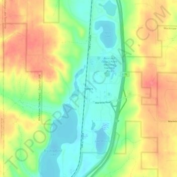
Nombre: Mapa topográfico Waters, altitud, relieve.
Altitud media: 414 m
Altitud mínima: 378 m
Altitud máxima: 454 m
Haz una donación
Otros mapas topográficos
Haga clic en un mapa para ver su topografía, su altitud y su relieve.
Gaylord
United States > Michigan > Otsego County
Gaylord became a city in 1922. The change from village to city required a vote by town residents. For reasons that are unclear, the margin of passage was a very close 21 votes — 114 people in favor to 93 against. John Hamilton was elected the first mayor of Gaylord. Over the years, the community continued to…
Altitud media: 401 m
Haz una donación
Gaylord
United States > Michigan > Otsego County
Gaylord sees significant snowfall during winter due to its elevation and its location in the path of lake-effect snow produced by Lake Michigan. Combined with local terrain and topography, many winter recreation opportunities abound.
Altitud media: 401 m
Haz una donación