
Haz una donación
Mapa topográfico Iron Mountain
Haga clic en el mapa para ver la altitud.
Haz una donación
Iron Mountain
Iron Mountain is included in the Marquette television market, NBC affiliate WLUC operates a local news bureau covering the city and neighboring areas. Due to distance from the transmitters and topography in the region terrestrial television signals are very limited in the area with the strongest signal coming from Wisconsin Public Television translator station W30DZ originating from Fence, WI.
Haz una donación
Acerca de este mapa
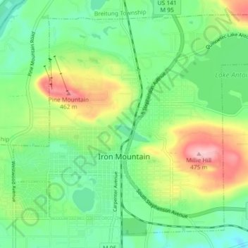
Nombre: Mapa topográfico Iron Mountain, altitud, relieve.
Lugar: Iron Mountain, Dickinson County, Michigan, United States (45.80456 -88.09815 45.84894 -88.02630)
Altitud media: 365 m
Altitud mínima: 304 m
Altitud máxima: 482 m
Haz una donación
Otros mapas topográficos
Haga clic en un mapa para ver su topografía, su altitud y su relieve.
Felch Mountain
United States > Michigan > Dickinson County > Felch Township > Felch
Altitud media: 354 m
Haz una donación