
Haz una donación
Mapa topográfico Oakland
Haga clic en el mapa para ver la altitud.
Haz una donación
Oakland
Oakland, owing to its high elevation and valley location, is among the coldest and snowiest locales in the state of Maryland, and has a warm-summer humid continental climate (Köppen Dfb). The state record low of −40 °F or −40 °C was recorded here on January 13, 1912. The monthly mean temperature ranges from 25.1 °F (−3.8 °C) in January to 68.4 °F (20.2 °C) in July, with temperatures not reaching above freezing on an average 34 afternoons and falling to 0 °F (−17.8 °C) or below on an average of 5.8 mornings. The average first and last dates for freezing temperatures are September 28 and May 15, respectively.
Haz una donación
Acerca de este mapa
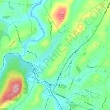
Nombre: Mapa topográfico Oakland, altitud, relieve.
Lugar: Oakland, Garrett County, Maryland, United States (39.39996 -79.42436 39.44366 -79.37775)
Altitud media: 763 m
Altitud mínima: 712 m
Altitud máxima: 879 m
Haz una donación
Otros mapas topográficos
Haga clic en un mapa para ver su topografía, su altitud y su relieve.
Hoye-Crest
United States > Maryland > Garrett County
Hoye-Crest is a summit along Backbone Mountain just inside of Garrett County, Maryland. It is the highest natural point in Maryland at an elevation of 3,360 feet (1,020 m).
Altitud media: 887 m
Haz una donación