
Haz una donación
Mapa topográfico McHenry
Haga clic en el mapa para ver la altitud.
Haz una donación
Acerca de este mapa
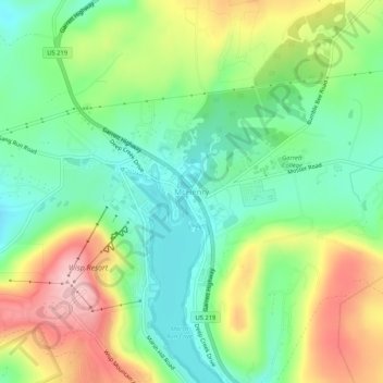
Nombre: Mapa topográfico McHenry, altitud, relieve.
Lugar: McHenry, Garrett County, Maryland, 21541, United States (39.53842 -79.37282 39.57842 -79.33282)
Altitud media: 817 m
Altitud mínima: 738 m
Altitud máxima: 943 m
Haz una donación
Otros mapas topográficos
Haga clic en un mapa para ver su topografía, su altitud y su relieve.
Oakland
United States > Maryland > Garrett County
Oakland, owing to its high elevation and valley location, is among the coldest and snowiest locales in the state of Maryland, and has a warm-summer humid continental climate (Köppen Dfb). The state record low of −40 °F or −40 °C was recorded here on January 13, 1912. The monthly mean temperature ranges…
Altitud media: 763 m
Haz una donación
Savage River State Forest
United States > Maryland > Garrett County > Grantsville
Altitud media: 738 m