
Haz una donación
Mapa topográfico Ocean Isle Beach
Haga clic en el mapa para ver la altitud.
Haz una donación
Ocean Isle Beach
Ocean Isle Beach is a picturesque barrier island characterized by its low-lying terrain and sandy shorelines. The topography features an average elevation of about 3 feet (1 meter) above sea level, with the landscape gently sloping towards the Atlantic Ocean. The island spans approximately 7 miles in length and about half a mile in width, bordered by the Atlantic Ocean to the south and the Intracoastal Waterway to the north. This unique positioning creates a blend of beach environments and marshlands, providing ample opportunities for outdoor activities such as swimming, kayaking, and fishing. The natural beauty and coastal charm make Ocean Isle Beach a serene retreat for visitors seeking relaxation and outdoor exploration.
Haz una donación
Acerca de este mapa
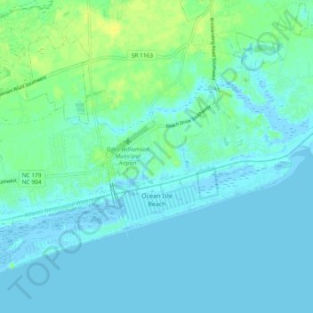
Nombre: Mapa topográfico Ocean Isle Beach, altitud, relieve.
Altitud media: 4 m
Altitud mínima: -6 m
Altitud máxima: 17 m
Haz una donación
Otros mapas topográficos
Haga clic en un mapa para ver su topografía, su altitud y su relieve.
Boiling Spring Lake Dam
United States > North Carolina > Brunswick County > Boiling Spring Lakes
Altitud media: 14 m
Haz una donación
Bald Head Island
United States > North Carolina > Brunswick County > Bald Head Island
Altitud media: 3 m
Haz una donación
Haz una donación
Haz una donación