
Haz una donación
Mapa topográfico Hood River
Haga clic en el mapa para ver la altitud.
Haz una donación
Hood River
Temperatures for the year as a whole are slightly cooler than in most other low-elevation towns in the region, especially at night because of air drainage off the surrounding mountains.
Haz una donación
Acerca de este mapa
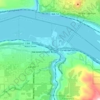
Nombre: Mapa topográfico Hood River, altitud, relieve.
Lugar: Hood River, Hood River County, Oregon, United States (45.69298 -121.56508 45.72651 -121.49538)
Altitud media: 112 m
Altitud mínima: 14 m
Altitud máxima: 504 m
Haz una donación
Otros mapas topográficos
Haga clic en un mapa para ver su topografía, su altitud y su relieve.
Mount Hood
United States > Oregon > Hood River County
Timberline Lodge is a National Historic Landmark located on the southern flank of Mount Hood just below Palmer Glacier, with an elevation of about 6,000 ft (1,800 m).
Altitud media: 2.716 m
Mount Hood
United States > Oregon > Hood River County
Timberline Lodge is a National Historic Landmark located on the southern flank of Mount Hood just below Palmer Glacier, with an elevation of about 6,000 ft (1,800 m).
Altitud media: 2.716 m
Mount Hood
United States > Oregon > Hood River County
Mount Hood, also known as Wy'east, is an active stratovolcano in the Cascade Range and is a member of the Cascade Volcanic Arc. It was formed by a subduction zone on the Pacific Coast and rests in the Pacific Northwest region of the United States. It is located about 50 miles (80 km) east-east-southeast of…
Altitud media: 2.716 m
Haz una donación