
Haz una donación
Mapa topográfico Mount Hood
Haga clic en el mapa para ver la altitud.
Haz una donación
Mount Hood
Timberline Lodge is a National Historic Landmark located on the southern flank of Mount Hood just below Palmer Glacier, with an elevation of about 6,000 ft (1,800 m).
Haz una donación
Acerca de este mapa
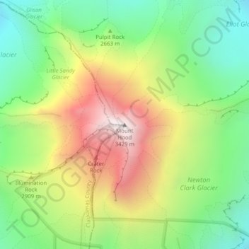
Nombre: Mapa topográfico Mount Hood, altitud, relieve.
Lugar: Mount Hood, Hood River County, Oregon, United States (45.37346 -121.69593 45.37356 -121.69583)
Altitud media: 2.716 m
Altitud mínima: 2.213 m
Altitud máxima: 3.416 m
Haz una donación
Otros mapas topográficos
Haga clic en un mapa para ver su topografía, su altitud y su relieve.
Hood River
United States > Oregon > Hood River County
Temperatures for the year as a whole are slightly cooler than in most other low-elevation towns in the region, especially at night because of air drainage off the surrounding mountains.
Altitud media: 112 m
Haz una donación
Hood River
United States > Oregon > Hood River County
Temperatures for the year as a whole are slightly cooler than in most other low-elevation towns in the region, especially at night because of air drainage off the surrounding mountains.
Altitud media: 112 m