
Mapa topográfico Lone Pine
Mapa interactivo
Haga clic en el mapa para ver la altitud.
Acerca de este mapa
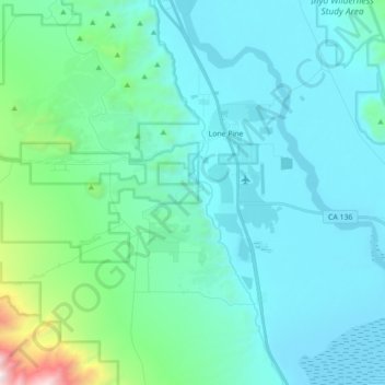
Nombre: Mapa topográfico Lone Pine, altitud, relieve.
Altitud media: 1.298 m
Altitud mínima: 1.084 m
Altitud máxima: 2.953 m
Lone Pine is a census-designated place (CDP) in Inyo County, California, United States. Lone Pine is located 16 mi (26 km) south-southeast of Independence, at an elevation of 3,727 ft (1,136 m). The population was 2,035 at the 2010 census, up from 1,655 at the 2000 census. The town is located in the Owens Valley, near the Alabama Hills and Mount Whitney, between the eastern peaks of the Sierra Nevada to the west and the Inyo Mountains to the east. The local hospital, Southern Inyo Hospital, offers standby emergency services. The town is named after a solitary pine tree that once existed at the mouth of Lone Pine Canyon. On March 26, 1872, the very large Lone Pine earthquake destroyed most of the town and killed 27 of its 250 to 300 residents.
Otros mapas topográficos
Haga clic en un mapa para ver su topografía, su altitud y su relieve.
Kearsarge Peak
United States > California > Inyo County
Kearsarge Peak, Inyo County, California, United States
Altitud media: 3.394 m
Badwater Basin
United States > California > Inyo County
Badwater Basin, Inyo County, California, United States
Altitud media: 152 m
Mount LeConte
United States > California > Inyo County
Mount LeConte, Inyo County, California, United States
Altitud media: 3.789 m
Kearsarge
United States > California > Inyo County
Kearsarge, Inyo County, California, United States
Altitud media: 1.159 m
Independence
United States > California > Inyo County
Independence, Inyo County, CAL Fire Southern Region, California, 93526, United States
Altitud media: 1.210 m
Death Valley Junction
United States > California > Inyo County
Death Valley Junction, Inyo County, California, United States
Altitud media: 627 m
Dante's View
United States > California > Inyo County
Dante's View, Inyo County, California, United States
Altitud media: 1.403 m
Lake Sabrina
United States > California > Inyo County
Lake Sabrina, Inyo County, California, United States
Altitud media: 3.033 m
Tecopa
United States > California > Inyo County > Tecopa
Tecopa, Inyo County, California, United States
Altitud media: 508 m
Mount Whitney
United States > California > Inyo County
Mount Whitney, Inyo County, CAL Fire Southern Region, California, United States
Altitud media: 3.903 m
Bishop
United States > California > Inyo County
Bishop, Inyo County, California, United States
Altitud media: 1.265 m
Owens River
United States > California > Inyo County
Owens River, Inyo County, California, United States
Altitud media: 1.183 m
Furnace Creek
United States > California > Inyo County
Furnace Creek, Inyo County, California, 92328, United States
Altitud media: -27 m
Crater
United States > California > Inyo County
Crater, Inyo County, California, United States
Altitud media: 1.657 m