
Haz una donación
Mapa topográfico Grosse Pointe Farms
Haga clic en el mapa para ver la altitud.
Haz una donación
Grosse Pointe Farms
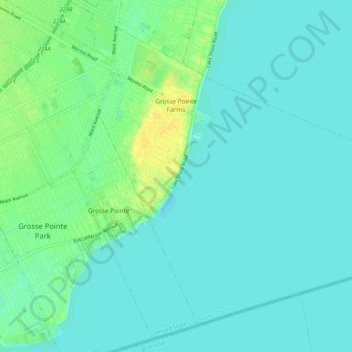
The Farms has a more varied topography and streetscape than the other southern Grosse Pointes. While Grosse Pointe and Grosse Pointe Park are built on a standard street grid and are basically flat, Grosse Pointe Farms is partially built on the same grid flowing out of Detroit, but also features districts with irregular, curving street paths. A low but noticeable ridge runs through the center of the city. The Farms also contains the "point" in Grosse Pointe, where, just east of the Grosse Pointe War Memorial, there is a large bend in the lakeshore, such that those on the shoreline face east, instead of south, as they do when on the shoreline of neighboring Grosse Pointe, closer to the entrance of the Detroit River.
Haz una donación
Acerca de este mapa
Nombre: Mapa topográfico Grosse Pointe Farms, altitud, relieve.
Altitud media: 177 m
Altitud mínima: 171 m
Altitud máxima: 192 m
Haz una donación
Otros mapas topográficos
Haga clic en un mapa para ver su topografía, su altitud y su relieve.
Haz una donación
Haz una donación