
Haz una donación
Mapa topográfico Mount Augusta
Haga clic en el mapa para ver la altitud.
Haz una donación
Acerca de este mapa
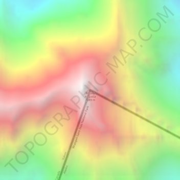
Nombre: Mapa topográfico Mount Augusta, altitud, relieve.
Lugar: Mount Augusta, Yakutat, Alaska, United States (60.30803 -140.45826 60.30813 -140.45816)
Altitud media: 3.300 m
Altitud mínima: 2.342 m
Altitud máxima: 4.245 m
Haz una donación
Otros mapas topográficos
Haga clic en un mapa para ver su topografía, su altitud y su relieve.
Hubbard Glacier
United States > Alaska > Yakutat
The longest source for Hubbard Glacier originates 122 kilometres (76 mi) from its snout and is located at about 61°00′N 140°09′W / 61.000°N 140.150°W / 61.000; -140.150, approximately 8 kilometres (5 mi) west of Mount Walsh with an elevation around 3,400 metres (11,200 ft). A shorter tributary…
Altitud media: 1.892 m
Malaspina Glacier
United States > Alaska > Yakutat
The Malaspina is up to 600 meters (2,000 ft) thick in places, with the elevation of its bottom being estimated to be as much as 300 m (980 ft) below sea level. There are two lakes on its margins: Oily Lake to the northwest, at the foot of the Samovar Hills between the Agassiz and Seward glaciers, and Malaspina…
Altitud media: 393 m
Haz una donación
Hubbard Glacier
United States > Alaska > Yakutat
The longest source for Hubbard Glacier originates 122 kilometres (76 mi) from its snout and is located at about 61°00′N 140°09′W / 61.000°N 140.150°W / 61.000; -140.150, approximately 8 kilometres (5 mi) west of Mount Walsh with an elevation around 3,400 metres (11,200 ft). A shorter tributary…
Altitud media: 1.892 m
Malaspina Glacier
United States > Alaska > Yakutat
The Malaspina is up to 600 meters (2,000 ft) thick in places, with the elevation of its bottom being estimated to be as much as 300 m (980 ft) below sea level. There are two lakes on its margins: Oily Lake to the northwest, at the foot of the Samovar Hills between the Agassiz and Seward glaciers, and Malaspina…
Altitud media: 393 m