
Mapa topográfico Holmes County
Haga clic en el mapa para ver la altitud.
Acerca de este mapa
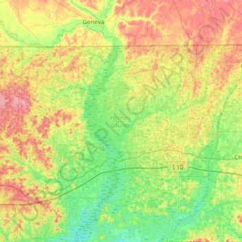
Nombre: Mapa topográfico Holmes County, altitud, relieve.
Lugar: Holmes County, Florida, United States (30.70298 -86.03773 30.99686 -85.49806)
Altitud media: 39 m
Altitud mínima: 3 m
Altitud máxima: 99 m
Otros mapas topográficos
Haga clic en un mapa para ver su topografía, su altitud y su relieve.
Palm Harbor
United States > Florida > Pinellas County
Palm Harbor is characterized by its unique topography, which features a relatively rare hilly landscape for the region. Unlike much of the surrounding areas in Pinellas County, which are predominantly flat, Palm Harbor includes elevations that can reach up to about 75 feet above sea level. This elevation gives…
Altitud media: 9 m
Navarre
United States > Florida > Santa Rosa County
Navarre is located at 30°24′04″N 86°51′47″W / 30.401°N 86.863°W / 30.401; -86.863Coordinates: 30°24′04″N 86°51′47″W / 30.401°N 86.863°W / 30.401; -86.863. It is located within a portion of the Florida Panhandle observing the Central Time Zone. Elevation is at an average of 10 feet (3.0 m).
Altitud media: 4 m
Port Charlotte
United States > Florida > Charlotte County
Port Charlotte is characterized by a predominantly flat and low-lying terrain, typical of Florida’s coastal landscape. The area features a network of waterways, including the Peace River and Charlotte Harbor, which provide ample opportunities for recreational activities like boating and fishing. Elevations…
Altitud media: 4 m
Nokomis
United States > Florida > Sarasota County
Nokomis features a predominantly flat and low-lying terrain characteristic of the coastal region. The elevation in Nokomis rarely exceeds 15 feet above sea level, contributing to its vulnerability to tidal influences and storm surges. The area is interspersed with wetlands and mangroves, particularly near the…
Altitud media: 5 m
Lutz
United States > Florida > Hillsborough County > Tampa
Lutz is characterized by a gently rolling topography that showcases the distinctive features of the central Florida landscape. The area has an average elevation of about 70 feet (21 meters) above sea level, contributing to its mild undulations rather than dramatic elevation changes. The terrain is marked by a…
Altitud media: 20 m
Parrish
United States > Florida > Manatee County
Parrish features a predominantly flat terrain with an average elevation of approximately 36 feet above sea level. The area's landscape is characterized by gently rolling hills and low-lying regions, making it typical of the Central Florida topography. Surrounding Parrish are numerous wetlands and drainage…
Altitud media: 12 m
Englewood
United States > Florida > Sarasota County > Englewood
Englewood features predominantly flat and low-lying terrain typical of the region's coastal landscape. The average elevation here is approximately 15 feet above sea level, which makes the area particularly susceptible to tidal influences and storm surges. The terrain is interspersed with wetlands and…
Altitud media: 3 m
Anna Maria island
United States > Florida > Manatee County
Anna Maria Island features a flat, sandy topography typical of a barrier island on the Gulf Coast. With an average elevation of around 15 feet above sea level, the terrain includes broad beaches, low dunes, and narrow stretches of sandy soil, making it highly vulnerable to storm surges and tidal flooding. The…
Altitud media: 2 m
Ponte Vedra Beach
United States > Florida > Saint Johns County > Ponte Vedra Beach
Ponte Vedra Beach is characterized by its gently rolling terrain that is primarily flat and lies only about 15 feet above sea level. The landscape is predominantly shaped by coastal dunes and the proximity to the Atlantic Ocean, resulting in sandy beaches interspersed with vegetation typical of barrier island…
Altitud media: 3 m
Key Biscayne
United States > Florida > Miami-Dade County
Key Biscayne lies south of Miami Beach and east of Miami. The village is connected to Miami via the Rickenbacker Causeway, originally built in 1947. Because of its low elevation and direct exposure to the Atlantic Ocean, it is usually among the first Miami areas to be evacuated before an oncoming hurricane.
Altitud media: 3 m
Jensen Beach
United States > Florida > Martin County
The Skyline Drive area includes some of the highest points in the community, reaching an elevation of 70 feet (21 m) at one point.
Altitud media: 5 m
Lake Ella
United States > Florida > Leon County > Tallahassee
In 1986, Lake Ella underwent extensive rehabilitation including sediment removal, reshaping of the shoreline, reducing the number of stormwater inflow pipes, and installation of an automatic alum treatment system. Lake Ella receives stormwater runoff from an urban watershed that is approximately 157 acres…
Altitud media: 56 m
Florida Keys
United States > Florida > Monroe County
Tropical cyclones present special dangers and challenges to the entire Keys. Because no area of the islands is more than 20 feet (6.1 m) above sea level (and many are only a few feet elevation), and water surrounds the islands, nearly every neighborhood is subject to flooding as well as hurricane winds. In…
Altitud media: 0 m
Lake Jackson
United States > Florida > Leon County
The lake is located in the Red Hills Region, and has fluctuated from periods of being dry to a maximum elevation of 96 feet (29 m) above sea level. The lake is approximately 7.5 miles (12 km) long and its area is 6.2 square miles (16 km2). There is no outflow from streams or runoff.
Altitud media: 45 m