
Mapa topográfico Lhasa
Mapa interactivo
Haga clic en el mapa para ver la altitud.
Acerca de este mapa
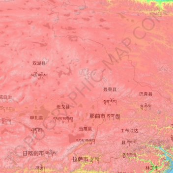
Nombre: Mapa topográfico Lhasa, altitud, relieve.
Lugar: Lhasa, Tibet, 850000, China (29.24065 89.75281 31.05753 92.62453)
Altitud media: 4.825 m
Altitud mínima: 3.538 m
Altitud máxima: 7.025 m
Lhasa prefecture-level city roughly corresponds to the basin of the Lhasa River, a major tributary of the Yarlung Tsangpo River. Exceptions are the north of Damxung County, which crosses the watershed of the Nyenchen Tanglha Mountains and includes part of the Namtso lake, and Nyêmo County, which covers the basin of the Nimu Maqu River, a direct tributary of the Yarlung Tsangpo. The river basin is separated from the Yarlung Tsangpo valley to the south by the Goikarla Rigyu range. The largest tributary of the Lhasa River, the Reting Tsangpo, originates in the Chenthangula Mountains in Nagqu Prefecture at an elevation of about 5,500 metres (18,000 ft), and flows southwest into Lhasa past Reting Monastery.
Otros mapas topográficos
Haga clic en un mapa para ver su topografía, su altitud y su relieve.
卡瓦格博观景台
China > Tibet > Zogang County > Pütog
卡瓦格博观景台, 甲应路, Pütog, Zogang County, Chamdo City, Nyingchi Prefecture, Tibet, China
Altitud media: 4.323 m
Chengguan District
Chengguan District, Lhasa, Tibet, 850000, China
Altitud media: 4.325 m
Shigatse
China > Tibet > Chengdong Subdistrict
Shigatse, Chengdong Subdistrict, Samzhubzê District, Shigatse Prefecture, Tibet, China
Altitud media: 4.055 m
Tibetan Plateau
China > Tibet > Nyima County > 尼玛镇
Tibetan Plateau, 尼玛镇, Nyima County, Nagqu City, Tibet, China
Altitud media: 4.475 m