
Mapa topográfico Chengguan District
Mapa interactivo
Haga clic en el mapa para ver la altitud.
Acerca de este mapa
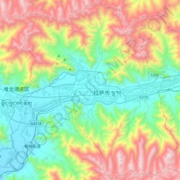
Nombre: Mapa topográfico Chengguan District, altitud, relieve.
Lugar: Chengguan District, Lhasa, Tibet, 850000, China (29.51215 91.01220 29.80326 91.30094)
Altitud media: 4.325 m
Altitud mínima: 3.614 m
Altitud máxima: 5.654 m
Lhasa is the second most populous urban area on the Tibetan Plateau after Xining and, at an altitude of 3,656 metres (11,990 ft), Lhasa is one of the highest cities in the world. The city has been the religious and administrative capital of Tibet since the mid-17th century. It contains many culturally significant Tibetan Buddhist sites such as the Potala Palace, Jokhang Temple and Norbulingka Palaces.
Otros mapas topográficos
Haga clic en un mapa para ver su topografía, su altitud y su relieve.
卡瓦格博观景台
China > Tibet > Zogang County > Pütog
卡瓦格博观景台, 甲应路, Pütog, Zogang County, Chamdo City, Nyingchi Prefecture, Tibet, China
Altitud media: 4.323 m
Shigatse
China > Tibet > Chengdong Subdistrict
Shigatse, Chengdong Subdistrict, Samzhubzê District, Shigatse Prefecture, Tibet, China
Altitud media: 4.055 m
Tibetan Plateau
China > Tibet > Nyima County > 尼玛镇
Tibetan Plateau, 尼玛镇, Nyima County, Nagqu City, Tibet, China
Altitud media: 4.475 m