
Haz una donación
Mapa topográfico Allegan County
Haga clic en el mapa para ver la altitud.
Haz una donación
Acerca de este mapa
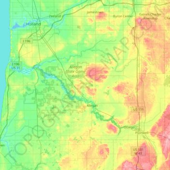
Nombre: Mapa topográfico Allegan County, altitud, relieve.
Lugar: Allegan County, Michigan, United States (42.41885 -86.27378 42.76894 -85.54305)
Altitud media: 219 m
Altitud mínima: 173 m
Altitud máxima: 318 m
Haz una donación
Otros mapas topográficos
Haga clic en un mapa para ver su topografía, su altitud y su relieve.
Haz una donación
Haz una donación
Genessee County Recreational Area
United States > Michigan > Genesee County > Genesee Charter Township
Altitud media: 231 m
Haz una donación
Mount Arvon
United States > Michigan > Baraga County > L'Anse Township
Mount Arvon (/ɑːrvɒn/ ARR-vahn) at 1,979 feet (603 m), is the highest natural point in the U.S. state of Michigan. Located in L'Anse Township, Baraga County, Mount Arvon is part of the Huron Mountains. It rises about eight miles (13 km) south of Lake Superior (elevation 591 feet [180 m]). On the list of…
Altitud media: 526 m
Charlevoix South Pier Light
United States > Michigan > Charlevoix County > Charlevoix
Altitud media: 180 m
Haz una donación
Haz una donación
Haz una donación
Haz una donación
Lower Peninsula Experimental Forest
United States > Michigan > Wexford County > South Branch Township
Altitud media: 314 m
Haz una donación
Haz una donación
Haz una donación
Haz una donación
Haz una donación
Haz una donación
Boyne Mountain
United States > Michigan > Charlevoix County > Boyne Valley Township
Altitud media: 263 m
Haz una donación
Haz una donación
Haz una donación
Haz una donación
Van Riper State Park
United States > Michigan > Marquette County > Michigamme Township
Altitud media: 489 m
Haz una donación
Grand Mere State Park
United States > Michigan > Berrien County > Lincoln Charter Township
Altitud media: 185 m
Haz una donación
Hulbert
United States > Michigan > Chippewa County > Hulbert Township
Hulbert is a rural community in western Chippewa County in the Upper Peninsula. The community is located within Hulbert Township about 40 miles (64 km) south of the Tahquamenon Falls. The community sits at an elevation of 751 feet (229 m) above sea level.
Altitud media: 231 m
Haz una donación
Anchor Bay Shores
United States > Michigan > Macomb County > Chesterfield Township
Altitud media: 176 m
Haz una donación
Lookout Point
United States > Michigan > Grand Traverse County > Peninsula Township
Altitud media: 188 m
Haz una donación
Metamora-Hadley State Recreation Area
United States > Michigan > Lapeer County > Metamora
Altitud media: 298 m
Old Mission
United States > Michigan > Grand Traverse County
Old Mission is located just east of M-37 near the tip of Old Mission Peninsula about 16 miles (25.75 km) north of Traverse City. The community was built along Old Mission Harbor, which is a small safe haven along the East Arm of Grand Traverse Bay. The community sits at an elevation of 587 feet (179 m) above…
Altitud media: 190 m
Haz una donación
Haz una donación
Felch Mountain
United States > Michigan > Dickinson County > Felch Township > Felch
Altitud media: 354 m
Haz una donación